Monday, February 27, 2023

Details on the additional snow for Tuesday and the growing likelihood of a 1-2 footer late on Friday into Saturday

We've found our groove here late in February, procuring a nice Sunday evening surprise and giving me the chance to post a gif from one of the best movies ever made. 

And yes, there's more to come. Though the February finale snow will not be the epic storm I hoped it would, it still looks to be a decent event. The big precipitation producing Midwest storm will transition part of its energy to the coast very early Tuesday. The coastal low pressure center never will achieve any notable intensity, but it will have a nice little pair of scissors and effectively slice off any push of mild temperatures before it reaches New England. The MRV high country will be left with some steady snowfall beginning around dawn Tuesday and persisting through part of Tuesday evening. The snow will be mostly light but steady enough to yield an additional 4-7 inches. The snow might be a little wet in valley locations (where lesser amounts are expected) but higher elevations will see a drier snow consistency producing another outstanding ski day. 

We've got more excitement in this outlook and its not that far away. Any early sunshine is expected to give way to more cloudiness on Wednesday and eventually some additional snowfall Wednesday evening. Temperatures will be a bit warmer during this round of precipitation and the snow will thus be a little wetter. Temperatures will actually rise above the freezing mark during the day Wednesday, as we greet the month of March, and are only likely to hover around the freezing mark Wednesday night with the 1-3 inches of snow we can expect before the ski day on Thursday. The snowfall Wednesday night comes from the first of two pieces of another major storm in the southern Rockies. What a season they've had down there and after depositing another couple feet of snow on the San Juan Mountains along with a few other places, this 2nd more vigorous piece of the storm will approach New England this upcoming Friday March 3rd. 

We have narrowed the range of storm tracks quite substantially for the storm late Friday, but most importantly, we got a northward shift to accompany this and are now looking at the likelihood of one of the better storms of the season. The low pressure center has the look of a southwest to northeastward moving "Miller B" type storms but this very optimal track will spread heavy snow over northern Vermont late in the ski day on Friday, with snow persisting into Friday night and Saturday. An early guess would be for a 1-2 foot type event and some additional clarity can certainly be gained once a final storm track is established. As of Monday afternoon, it certainly appears that the upcoming weekend will be the best of the season with temperatures now likely to remain below freezing across the high country both Saturday and Sunday. 

Every period continues to trend in a cooler direction over the next 2-3 weeks and although we still might see an above freezing afternoon, such as the one we expect Wednesday and again next Monday, the idea of a March melt-off appears delayed until after mid-March. The next chance for some snow appears to be late Monday (March 6th) into Tuesday the 7th and then the jet will undergo a more substantial jet amplification by Friday, March 10th. The recent -PDO years have really limited these type of jet stream regimes over North America, but this appears to be a very impressive -EPO period and it will ensure an extended stretch of below normal temperatures across a broad area of North America as NWS has foretasted a few days ago while also setting the stage for additional east coas weather drama.  The relative SST warmth of the western Atlantic Ocean is just another stick of dynamite.


Saturday, February 25, 2023

Weather pattern aligning for some good times in March, but the party starts early with a snowy last Sunday of February

For much of the last two months, the prevailing weather pattern has presented Vermont with so many roadblocks that even the rare snowy stretches seemed like an obstacle course to the finish line. With the arrival of March and as always, with impeccable New England weather irony, the roadblocks fade away and the horizon is dotted with more chances for snow than I can even keep track of. Over the next week to 10 days, the pattern is anchored by a negative NAO working overtime to mitigate the pesky ridge across southeast North America, but eventually the jet stream in the Pacific fizzles sending, the EPO index plunging into negative territory and favoring both cold weather in the eastern part of our continent and snowfall over New England. Even the National Weather Service, typically rather conservative regarding predictions of cold or anomalous weather in the long range is throwing out a map encompassed by a sea of blue in the middle or March over the entire United States minus Florida. This an incredibly bold prediction (several weeks out) in a time frame that usually falls outside the of a window where a weather forecast can provide much value, but the folks at NOAA who put this together obviously feel confident about where the MJO is headed and how various ensembles are handling some of these Pacific feedbacks going forward. With all that said, let this March party begin ! 


And the additional snowfall starts Sunday from what appears to be a small disturbance, but one capable of really enhancing low level instability over the northern Vermont high country. Snow should begin falling shortly after first chair, and is expected to continue for much of the day and into the evening on the mountain even as snow flurries mix with some intermittent sunshine over valley locations. Based on the instability parameters, one could make a case for a big positive surprise over the high country with some occasionally heavy snow squalls leading to 6 or more inches. I would favor that kind of outcome a bit farther north, but Sunday on the mountain should consist of a fluffy kind of snow, likely to exceed 3 inches. Hopefully we get surprised, conditions are there for it ! 

The Tuesday February 28th storm has trended the other way unfortunately. Doesn't appear as if we get shut out, but also certainly doesn't appear that this will turn into the storm of the season. Instead, the initial big low pressure area set to move over the Great Lakes will mature, weaken and transition much of its energy to a coastal low that will get squeezed eastward and will never get the opportunity to evolve into a full-blown nor'easter. Snowfall should envelop Vermont Tuesday and persist through much of the day, but should never become especially heavy and accumulations are more likely to be in the 3-6 inch category. Not a bad addition to our recent stretch of snow, but not a headline. 

The arrival of March will fittingly bring some above-freezing temperatures, aided perhaps by a rare appearance of morning sunshine in this very active weather pattern. More storminess and more cloudiness should quickly envelop the region however and by the end of the first day of March, we can expect more precipitation, most likely falling as snow across the mountains producing a few more inches for the Thursday ski day. 

Thursday March 2nd into early Friday March 3rd appear to be weather-free though clouds are likely to persist over northern New England. The next storm approaching from the southwest later Friday appears especially potent with a massive swath of heavy precipitation. This storm very possibly could achieve what Tuesday failed to do, but the track of this system remains very uncertain with some models confining the impact of this system to the southeast U.S. while other models are prepared to deliver northern New England a 1-2 footer for the weekend. 

In the last update, I had indicated a possible more spring-like warm period for the first full weekend in March. No doubt, model data has moved in a cooler direction especially next Saturday and Sunday, but there are still indications that the southeast ridge takes one last breath before succumbing to the aforementioned changes in the Pacific. It really isn't especially hard to string together a few 40-plus afternoons in March and this still appears possible early in the first full week of March (5th and 6th). After that, the weather pattern favors much of what the National Weather Service is advertising in that bold map they issued. Cold weather of a broad scope and something we really haven't seen since prior to Christmas.  The weakened Pacific will send a few southern streamers our way, bringing us the additional chances for snow as we approach the middle of March.


Thursday, February 23, 2023

A snowy, wintry next 6 days of weather highlighted by storm potential as February transitions to March

Heard a few folks on the MRG single line saying they were a bit underwhelmed with snowfall totals Wednesday night and I don't disagree. Even late last night I thought we had a decent chance to outperform expectations, but drier air appeared to weaken the area of overrunning snow just a little, though the 7-8 inches that fell skied very nicely. And our storm continues through Thursday afternoon and into the evening and overnight. There is a weak and pesky warm layer that is expected to linger over central Vermont just enough to allow the light snow to mix with some sleet for a time this evening. After midnight however, shallow boundary layer instability combined a very favaorable northwest flow off Lake Champlain will combine to produce a few hours of decent snowfall, especially over the high country. If we can manage to avoid any sleet, I'd be willing to predict another 3-6 inches by first chair Friday, but I can't assume the best and am inclined to anticipate a more conservative 2-4. Arctic air should really dry it out by late morning with blustery conditions, temperatures near 10 and increasing amounts of blue sky. Actually, I've really come to appreciate those type of days after some fresh snow cover, especially since they've been in short supply this year. 

Skies should stay clear just long enough to allow temperatures to drop as low as -10  n a few spots Saturday morning and to allow some sunshine to warm readings back into the teens Saturday afternoon, but a lot of weather is being aimed in our direction over the next week and clouds are expected to return later in the day Saturday. It doesn't seem like we can spin up a significant snow producing system this weekend, but some light snow is possible Saturday evening yielding little accumulation and then more light snow is probably Sunday yielding potentially a small accumulation. Sunday's snow comes from a disturbance diving southward out of Canada and my optimistic ski goggles tell me the mountain could score a few fluffy inches from that, some of which might fall after the ski day. 

The more interesting period weather-wise continues to be the time frame beginning Monday night (Feb 27) and persisting through Wednesday March 1st. A downstream block in the jets stream will help push this storm southward while a lingering jet stream ridge in the southeast U.S. pushes this system northward effectively squeezing it through our open window. As I expected, none of the models are threatening us with the R word anymore and the concern really just involves our proximity to the deeper plumes of moisture this storm is sure to produce. Initially this weather system will approach us as a very wound up and mature cylcone from the Great Lakes region, but the storm will transition some of its energy to the southern New England coastline by early Tuesday while the matured and eventually decaying system slowly approaches northern New England. There's a big ceiling with potential snowfall expectations less because the strength of this storm but rather the nature of this slow-moving weather system operating underneath the downstream blocking. We still could miss everything or most of everything, but the established consensus for now has us on the northern end of some decent snowfall. Hopefully it evolves into the one we've been waiting for. 

The weather pattern has promise moving forward into March but there's a period bound roughly by Friday, March 3 and ending around March 7th that has moved toward the milder side, mainly because the core of arctic chill shifts westward and west of the Hudson Bay allowing more milder spring-like weather to move northward (occasionally reaching VT). The blocking -NAO structure remains and will have to work hard to suppress more storminess that is expected to approach for the full weekend in March. The "R" word is more likely with this event though I would favor a combination of precipitation types as a very initial guess. Ensembles really work to tame the Pacific beginning March 8th and when combined with high latitude blocking that is expected to remain in place (at least some), winter remains an unfinished work, at least around these parts. Expect more talk of storms as we proceed toward the 30th anniversary of the best winter storm to impact me !


Tuesday, February 21, 2023

10-18 inches of snow by early Friday and big storm potential next week !

We are diving head first into a late winter, downstream blocked, -NAO pattern and even before we really hit the water, we are expecting some decent snowfall. Lots of questions in the longer range about how well we can optimize this more favorable setup, but the weather picture for the rest of this week has certainly attained more clarity and a Winter Storm Watch now covers all of central and northern Vermont. 

The clipper system responsible for that bit of snow (1-3 inches) Tuesday evening will help bring colder air down from eastern Canada into northern New England. The very warm (relative to the season) Great Lakes aggregate is a feedback that has helped repel attacks of colder weather, but this particular airmass can work its way around that area of relative warmth and envelop much of Vermont more directly by Wednesday morning, and temperatures for much of the day should stay in the 20's under high clouds. There's been a lot of talk about the impressive temperature gradient over the eastern United States and this should begin to take shape on Wednesday and will help to fuel this expansive weather system which will be positioned near Chicago during the evening. This intense clashing of airmasses will help fuel the overrunning snowfall which will should begin within a few hours of 10 pm Wednesday and continue steadily and occasionally heavily during the overnight. The snow will become lighter and may stop altogether during the ski day, but at that point 8-12 inches of the good stuff will be on the ground with temperatures hovering around 20 degrees. Some of the higher resolution data has been clashing with the consensus already reached by global models involving the track of this storm. I've been pretty convinced the MRV is positioned in an optimal place for snowfall out of all this, but the higher res data has been poking the area with mid-level warmth because the storm is being simulated to track on a more northerly course. I've been reassured that this will not be a significant issue as of Tuesday afternoon, but a period of sleet is possible early Thursday though temperatures should remain well below freezing. 

There is a 2nd piece of this storm which will bring more snowfall to the region Thursday evening. The heaviest snowfall in this time frame is likely to be closer to the Canadian border but the MRV is positioned to get an additional 1-3 inches during the evening and then as winds turn north to northwesterly early Friday, moisture from the unfrozen and very warm (for the season) Lake Champlain will bring an additional 1-3 inches of snowfall. Add all of this together and we have a 10-18 inch storm total (8-12 Wednesday night, 1-3 Thursday evening and 1-3 Friday morning). Friday and Saturday are setup to be chilly with temperatures holding in the lower teens Friday, falling below zero Friday night and climbing back into the teens Saturday. I want to promise the return of some sunshine but this is a very busy weather pattern and the weekend is likely to feature a lot of clouds and some additional light snow both days. Some light accumulations are possible but I don't see more than 3 inches. 

Ensembles have become more aligned around the idea of a massive storm that would initially mature in the Upper Midwest, but duck under the strengthening downstream block and become a big rain and snow producer for all of New England, beginning as early as late Monday February 27th and extending into Wednesday, March 1. Operational models are throwing in a warm, rainier scenario or two and this appears most likely for coastal areas of New England. There is a history of storms in this type of setup to be terrific snow producers for the interior mountains and this event, about a week from now, has that kind of potential. As mild and as disappointing as this winter has been across eastern North America, I would still be surprised to see this storm turn into a rainmaker and would be more concerned about the track of this storm shifting south, farther underneath the blocking. Needless to say, this should have our attention in the days ahead as a storm that could prove to be the biggest of the season for us. 

And the pattern might not be done after that with storminess indicated to continue into the first 10 days of March. Like many -NAO patterns, the temperature outlook doesn't look especially cold, but the pattern is supportive of additional chances for snowfall and there are growing indications of another potential event the first full weekend of March

Sunday, February 19, 2023

Next 10 days looks outstanding in northern VT with heavy snowfall close to a lock late this week and more potential this weekend/next week

Winter is about to roar back to life in northern Vermont with heavy snowfall close to a virtual certainty on Thursday and I am hopeful that we can expand the good tidings past this week and into early March. We certainly have some of the right ingredients with blocking expected to emerge over Greenland allowing the NAO index to move decisively into negative territory. A similar pattern emerged in March of 2018 following a rough month of February and Mad River Glen received over 80 inches of snow.

The President's Day holiday Monday is still mild one, especially across valley locations where readings are expected to climb into the lower 40's. It won't be quite as warm across the high country however and a brief period of above-freezing temperatures late in the morning into the early afternoon will be replaced by elevation sensitive snow showers late in the ski day. A mostly wet inch of snow is possible by 4 pm and another inch or two is possible during the evening as winds turn and blow more favorably off an unfrozen Lake Champlain. Though temperatures may climb above freezing again in valley locations Tuesday, I don't see this occurring across the high country tomorrow or the rest of February. 

A stronger clipper system is expected to bring more snowfall late on Tuesday. This will occur after several hours of sunshine in the morning and a few more hours of cloudiness early in the afternoon. The snow Tuesday is expected again late in the ski day into the early evening and is likely to accumulate 2-4 inches. The better moisture with this system is actually south of us and portions of the southern Green Mountains and Berkshires could receive up to 6 inches. The storm will also return arctic air into northern New England for Wednesday and help establish a critical jet max over the maritimes of Canada capable of ensuring that the cold airmass that is expected to build over eastern Canada remains entrenched over northern New England late in the week. 

The strong late week winter storm has some similarities to the early February event last year in that both produced an intense temperature gradient over the eastern United States. This storm, like the one last year, will feature an elongated west to east area of low pressure,  that will torch locations with 80 degree temperatures over portions of Virginia, the Carolinas and points southward. Vermont might as well be living on a different planet with arctic air actually strengthening its grip on the region as snow arrives very early on Thursday.  Northern Vermont is positioned beautifully for an extended period of overrunning snowfall beginning in the pre-dawn hours Thursday and extending into early Friday. It's a storm featuring La Nina's best personality trait after a month where we saw La Nina at its absolute worst. In terms of snowfall amounts, some caution should be advised as changes could occur in the next few days, but we've seen a good consensus emerge over the last 24-48 hours for a widespread 1-2 foot event for northern Vermont. Some sleet is possible for the MRV but this is more likely and more problematic in central and southern Vermont. Temperatures after early Thursday will generally be in the teens and drop into the single numbers as snowfall ends Friday ensuring a rather dry snowfall event. Arctic air then dominates the weather picture Friday night into early Saturday dropping temperatures well below zero on Saturday morning before sunshine warms readings back into the teens in the afternoon (It will not be a repeat of the arctic event Feb 3-4). 

There's plenty more potential action after the Thursday/Friday event this week with clouds returning to the region late on Saturday February 25th and some new snowfall possible for the ski day on Sunday, the 26th. The European Ensemble is, as of late Sunday producing an exceptional signal for something very significant on Tuesday February 28th. This is not receiving much support from the American Ensembles though there is some hints of an event on the Canadian Ensembles. More generally, it is the European that has for the last several days, indicated a more beneficial snowfall and temperature outcome for northern New England from this upcoming -NAO driven pattern. I will suggest however that there is some similarities to the December -NAO which favored arctic air more in western North America and kept northern New England cool but not cold relative to climatology. We are likely to see another cold intrusion following the potential storm February 28 but are likely to see some milder March days scatter themselves into the weather picture as well, especially as we get toward the first full weekend of the month (4th and 5th). Overall though, its hard to complain about the outlook for the next 10 days and the benefits of this setup could certainly extend out further into March.


Friday, February 17, 2023

Colder weather has returned to the MRV, just in time for another more wintry update !

The MRV has made it clear to the other side of yet another brutal stretch of 2022-23 non-winter weather. Yet I awoke to an apparent social media universe filled with negative nancies and white flag waving willies and this gives me the chance to post a random gif of Apollo Creed's trainer Tony "Duke" Evers yelling for the towel in his famous match against Ivan Drago !


And no I will not throw it !. The weather pattern appears a lot more favorable for snow across New England with a sudden stratospheric warming event having occurred, favoring colder weather at mid-latitudes more generally while the jet stream in the Pacific is expected to weaken and NAO expected to turn negative. Most importantly, snow has entered the forecast picture in the more immediate as opposed to long range horizon. Not in time for the holiday weekend perhaps, but as soon as  late Tuesday, February 21st. 

Lots of clouds in that forecast for next week, but one thing the holiday weekend does have is sunshine, a full day of it on Saturday and at least a partial day of it Sunday. Seasonable temperatures can be expected for Saturday while southwesterly winds on Sunday move temperatures above the freezing mark and up near 40 on Sunday. Clouds return for President's Day, but the rain and snow showers should hold off until very late in the ski based on the current look of things. Precipitation across the high country after the ski day should be mostly snow showers, coming from a clipper system, the first of two that is expected to impact the region early next week. This first clipper will bring just minimal snowfall but it will bring temperatures back into the 20's for most of Tuesday ahead of the approaching 2nd clipper system which appears more interesting. 

There's lots of weather after President's Day and the snowfall late on Tuesday or early Wednesday is likely to be on the lighter side. Forecast models continue to struggle with all the different disturbances rapidly moving through the jet stream but I do tend to like the recent European model scenario of snowfall for the MRV beginning Tuesday night and amounting to a few inches by Wednesday. As conditions dry out later Wednesday, arctic air positioned over Canada will make a southward push into interior New England, just out ahead of the much bigger area of storminess approaching from the Midwest. There's understandable consternation regarding the next big east coast precipitation producer on February 23rd because of the large area of warmth in the southeast making another northward push. The difference this time ? A large confluence area in the jet stream known as a "jet streak" predicted to set up over the maritimes which will ultimately make it very difficult to dislodge the cold over northern Vermont (yes, the southern New England coastline is doomed again). It's a closer call than I would like certainly, but a potentially fruitful situation for us in the MRV with new snowfall coming both Thursday and Friday, possibly significant. Yes, there is a chance for a period of mixed precipitation, but I would not expect temperatures to move beyond the freezing mark late next week for any lengthy period of time. 

Arctic air is indicated to arrive in the wake of whatever outcome we receive late next week giving the early part of the last weekend in Feb a cold look (Feb 25). The colder weather is then indicated to abate for Sunday into Monday February 27th before colder weather is reinforced for the rest of that week. The negative NAO will become a more significant player by this point so it will be interesting to see what can be spun up in that time frame.

Wednesday, February 15, 2023

Outlook trends in a more wintry direction for the end of the month with new snowfall expected as early as Friday and additional chances thereafter !

If we can stay focused on the last update and use it as our reference point, this update is a pretty darn good one. El Torchy is taking no prisoners Wednesday and is ravaging most of New York state with 60-plus temperatures. Clouds have given Vermont a layer of protection from the excessive spring-like weather Wednesday but strong south to southwest winds are expected to blow some of that warmth into the MRV for a few hours this evening and into the overnight. Aside from that news however, almost every other part of the outlook is colder or more wintry or both, even for the shorter term. 

The battle between those El Torchy conditions in eastern North America and the more wintry conditions out west (even Vegas got in on that act yesterday) is and will be delineated by two areas of low pressure, the first of which traveled through Quebec on Wednesday while the second will exit the Rockies proceed into the southern plains and track northeastward toward New England Thursday. The forecast track of this second area of low pressure has trended southward and the just released Euro model has the storm over the Berkshires Friday morning. While other models are farther north, they have participated in this southward trend and this changes the weather picture even for Thursday when we are expecting some colder air to ooze southward and keep temperatures in the 30's in the MRV as opposed to the near 50-degree air I expected over us a few days ago. So can we pull off the miracle and get snow from this on Friday ? The chances certainly aren't zero and as you move northward to Stowe, Smuggs and Jay Peak, those chances increase.  Currently, rain is still expected to begin early Friday but a low level push of colder air is likely to change that precipitation to freezing rain, maybe some sleet and eventually a period of snow. That snow could be significant from Stowe northward and if this southward trend continues, we could steal a much needed 4-8 snow storm out of this miserable winter weather setup. I am not predicting that yet but at least it's possible and more likely as you travel northward. 

The other part of the shorter term outlook that has trended in the right direction has to do with early next week which continues to look mild but does not appear to include any more excessive thawing. The weekend will consist of a seasonable but blustery and sunny Saturday and a milder Sunday including readings on the mountain that climb into the 30's. A clipper system is expected to bring clouds for President's Day and temperatures are expected to hover above the freezing mark on the mountains while reaching the 40's in Valley locations but I don't see a risk for any substantial rainfall. Instead, elevation sensitive rain and snow showers appear likely followed by cooler temperatures Monday night into Tuesday. As next week progresses, which is a holiday week for some, colder air will continue to ooze southward and eventually the later part of next week and following weekend will see arctic air envelop the MRV. Models are having a difficult time sorting through specifics regarding the storminess next week but we are positioned rather well to receive a needed dose of new snow in the middle or later part of the week from one or two nice looking waves of low pressure capable of spreading significant overrunning snowfall to interior New England. 

Convective activity in the south Pacific is expected to shift the MJO into a more favorable phase for winter weather over all of North America and there continues to be evidence that the coldest air is favored over western North America, New England also looks chilly and wintry to finish out what has been another mild month. With milder temperatures continue to linger over the southeast, consistent with the finest La Nina tradition, it does set up New England rather nicely to be on the receiving end of some late season winter storms. This has been a tough stretch, but it's not yet game over !

Monday, February 13, 2023

48 hour thaw expected late this week while colder weather and snowfall potential are mostly confined to late February, after the holiday

I feel like this blog has inadvertently turned into marketing propaganda for ski areas across the west,  but speaking honestly, it's been a good snow year for them and a bad one for us. Telluride is reporting 170 inches of snow so far this season and Wolf Creek 250 (which is a lot even for them)but the upcoming week is expected to be the best of the season from there southward through Taos in New Mexico where multiple weather systems are expected to deposit 2 feet or more. Flagstaff enjoys a much different climate overall than a town like Warren or Waitsfield in Vermont but average seasonal snowfall is somewhat similar and that 8,000 foot town in Arizona is also expecting 1-2 feet of snow by Wednesday morning. I point all this out because whenever the jet stream because supportive of these types of snowfall totals across the southwestern United States, Vermont certainly becomes at risk for a thaw. It doesn't happen all the time since jet streams can split and the weather out there can operate totally independent of ours, but this happens to be a case their good fortune comes at our expense. 

With the exception of a few weeks, the pattern has been relentless in its support for milder temperatures across eastern North America but the stretch of warmth late this week will not be remembered with any affection. We saw a subfreezing overnight Sunday night into Monday morning and we can expect two more Monday and Tuesday nights before the extended thaw begins Wednesday during the day. An interesting little disturbance is expected to dive southward out of southeast Canada Monday evening and the prevailing flow does support a few inches of snow across our high country before the ski day on Tuesday. Temperatures profiles suggest this snow to be on the wetter side at most elevations, but above 3000 feet, those few inches are likely to be more powdery and those same highest elevations are also the most likely to stay below the freezing mark all day on Tuesday even as sunshine warms valley locations to 40 degrees. 

Clouds are expected to return for the thaw on Wednesday, but increasing winds out of the southwest will blow both milder temperatures and higher dewpoints in our direction. Readings will climb into the 40's at most elevations, enough to soften snow conditions on most of the mountain. We will manage to avoid most of the rain Wednesday and Thursday with precipitation limited to intermittent light rain Wednesday while mainly dry weather is expected Thursday. Unfortunately, Thursday will feature the combination of excessive temperatures (50's ! ), steady southwest winds and 40-plus dewpoints. This is then followed by a period of more steady and occasionally heavy rain (even a Thunderstorm) Thursday night/early  Friday before colder arrives Friday afternoon. We could see a few inches of snow accompanying the colder push of temperatures late on Friday but snowfall totals are unlikely to exceed 4 inches. 

There continues to be signs of a slight pattern realignment further out on the horizon, I'll explain more in the paragraph below, but the return of modified arctic air this weekend is expected to be short-lived with another big surge of milder temperatures expected for early next week. Models have gone back and forth on whether the core of this next excessive round of milder weather reaches Vermont on President's Day, Monday February 20th into Tuesday February 21st; in fact, model consensus has trended in the "not as warm" direction over the past 24 hours but the chances for significant snow are quite low. 

After the holiday period, there are clearer signs of a change. Interestingly the pattern continues to look unblocked at high latitudes and though the jet stream in the Pacific is expected to be weaker past the holiday, I would categorize it as neutral rather than favorable. The core of arctic cold across Canada will strengthen next week however and, according to an aggregation of ensembles data, push southward over the northern latitudes of the United States slowly. The milder temperatures are indicated to persist over the southeast for most of the rest of the month, but New England is expected to see temperatures return to normal by the 23rd or 24th of the month and below normal temperatures are indicated the last few days of the month. Storminess is indicated to persist for the last 7 days of the month giving Vermont a few cracks at natural snowfall before March.

Thursday, February 9, 2023

Tough outlook remains in place through Feb 17, but colder air and snow potential returns for last 10 days of Feb

A couple of hours of wet snow Thursday is the consolation prize we are receiving for our latest rain event, coming on the heels 20 below normal temperatures, it hurts a little more. The wet snow could come down hard for a short period of time and even accumulate an inch or two, but there is no escaping an evil warm layer expected to overspread the region by the time it gets dark Thursday. Precipitation in most areas is expected to become rain though the inversion is expected to remain in place for a good part of the overnight which keeps the door open for freezing rain and ice over the high country. Sometimes the inversion sets up so that elevated locations warm up first but this appears to be a case where the mountains have the best chance of getting an ice accumulation. The heaviest precipitation over and done with by 2 am Friday and even the lighter rainfall will push off to the northeast before daybreak. A mild westerly wind is expected to dry things out a bit during the day Friday and warm temperatures up into the 40's. A few breaks in the overcast, which certainly seems possible, could boost temperatures further. 

Most of the weekend is expected to be sub-freezing with the exception of a few hours Sunday afternoon at lower elevation. Clouds should clear away Saturday with readings in the 20's while an intense area of low pressure develops over the southeast U.S. keeping the clouds away from us and allowing for a clear and more seasonable Saturday night into early Sunday. Yes, we said a few prayers for this aforementioned storm, but the fact it will become detached from the jet stream is not one of those fruitful scenarios.  The European model continues to slow the eastward progress of this rain and wet snow producing system which is expected to position itself near the Virginia Tidewater on Sunday and this means that models not totally sorted out all the specifics, but the consensus continues to keep the moisture south of Vermont and the brief colder interlude this weekend is expected to get overrun with mild air at the beginning of next week.

Every day next week is now indicated to feature at least a period of above-freezing temperatures and the risk for an excessive thaw featuring  at least 48 consecutive hours of 40-plus temperatures, rain and wind continues to rise. A big storm is predicted for the southern Rockies toward the middle of next week amplifying the jet stream configuration in North America in a bad way. It's terrific for the southern Rockies and awful for us in northern New England. Doesn't appear to be a game over situation though for winter (more on that in a minute) and even next week, as bad as it looks is not a guaranteed meltdown yet. The big storm in the southern Rockies is expected to push east and track up through the St Lawrence Valley, spreading excessive warmth out in front of it, but the St Lawrence Valley is 150 miles away, not 500.  Move one or two shortwaves in the jet stream different directions on the weather map and the pattern could end up flatter with a more mitigated thaw. I've certainly seen it happen. 

Arctic air looks like it will then make a return for the weekend of the 18th and 19th of February. We are looking at a partial pattern realignment and certainly a colder outcome, but the polar air will have to battle it out with mild temperatures that are expected to remain in the southeast. It's more classic La Nina, but at least we got a chance to spin up a snow event in that setup where as next week appears very, very challenging.

Tuesday, February 7, 2023

Brutal 10-day outlook for New England with a colder forecast picture beginning to emerge after February 17

Optimism remains in short supply over the next 10 days regarding winter weather in Vermont. An inch of mostly wet snow remains likely across the high country Tuesday night and temperatures will remain in close contact with the freezing mark during the ski day on Wednesday though readings will make a run at 40 in the valley locations. On Thursday we are looking at a 20 degree morning with some limited sunshine and then we are enveloped by cloudiness as temperatures inch above the freezing mark. Precipitation is indicated to arrive sometime Thursday evening and vertical temperature profiles are showing the possibility of some icing, especially up off the valley floor. The ice should eventually change to rain everywhere but the wet weather doesn't appear as damaging as the 40-plus temperatures we are expected to experience on Friday. Friday actually appears to be a drier day now as much of the precipitation is indicated to push off to our north and east. A few hours of sun on Friday could push readings as high as 50 on the valley floor though the mountains should remain considerably cooler than that. 

Though the prevailing pattern is highly unfavorable and will remain so through next week, we had some hope for a period of significant snowfall associated with an incoming surge of colder air Friday night into Saturday. Data continues to show the cold day for Saturday but have decisively reduced the probability for any snowfall. The potent jet impulse responsible for igniting that 2nd area of low pressure remains a big part of Friday's weather map but the resulting storm appears farther south and east and barring a big northward shift, the weather for the weekend appears drier and sunnier. Snowfall could have been very helpful in disguising any rain or ice damage and at this time it does not appear we are in line for very much. 

There continues to be strong evidence pointing to a big jet stream amplification over the western United States early next week and this is certainly supported by the evil empire (+EPO) setup in the Pacific. It's been a very good snow year for many ski areas out west and next week will be another good one for them and bad one for us. Hopefully the jet stream is indicated to become a little flatter next week which would allow us to mitigate what appears to be a very broad area of mild air encompassing eastern North America. If we can't move toward this flatter jet stream, multiple days of excessive warmth along with rainfall will dominate the forecast picture late next week. Its got the potential to be very ugly but it remains far enough out on our timeline for some changes to occur. Meanwhile, I am still cautiously optimistic about the buildup of colder air over Canada towards the middle of the month and continue to see some potential that arctic could play a bigger role in our weather after February 17. There is little evidence that the pattern will shift outright to a favorable east coast snow environment, but I remain of the opinion that northern New England is positioned to see some action later in the month.

Sunday, February 5, 2023

Short term outlook has improved somewhat but the weather picture over the next 10 days remains a challenge

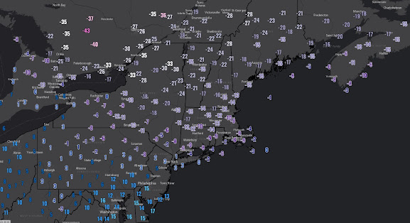
In an otherwise mild winter, Vermont and the rest of New England got slammed with one of the more intense outbreaks of arctic air this century and it stands up pretty well against many of the big ones in the 20th century. Even stations such as Boston's Logan Airport, now in its 100th year of operation (with 100 years of weather data), saw readings drop to -10 early Satuday shattering the lowest recorded temperature for the date by 8 degrees. Mt Washington has data going back 75 years and the -47 F degree reading early Saturday morning was the coldest ever recorded at the station at any time while the -110 degree wind chill scored international headlines and viral videos. Below is a map of low temperatures Saturday morning across the northeast U.S. and southeast Canada (Thanks Ian Livingston of the Capital Weather Gang). 


The MRV saw temperatures stabilize around -20 early Saturday morning before rising above zero and continuing that rise Saturday night. By Sunday afternoon, many areas were above freezing bringing to mind the famous line from the 90's movie The Usual Suspects.... "and just like that, he's gone". 

I don't have a ton of nice things to say about the prevailing weather pattern for the next two weeks and the blogosphere can get a little high on superlatives anyway, but lets just call it a challenging situation through Friday, February 17th. The upcoming week is mild, but at least the high country will mix in intervals of sub-freezing temperatures. Across the high country, most of Monday and Tuesday is sub-freezing and a clipper system approaching late on Tuesday is actually going to bring an inch or two of snow for the ski day on Wednesday. The concern for the shorter term forecast picture relates to Friday as a low pressure conglomeration arrives as arctic air continues a slow retreat northward in Canada. During the last update, I did include a poorly worded discussion conveying some potential with the weather situation on the weekend of February 11th and 12th, but with cold continuing to erode on Thursday into Friday, it will be difficult for precipitation to begin as anything but freezing rain or rain. I would expect this wet weather to begin late Thursday and continue into early Friday with temperatures generally staying in the 30's or 40's.

Things get more interesting later Friday into Saturday as a stronger piece of jet energy arrives along with marginally colder air. Models remain divided on how all this plays out but over the last several days, there's been a loose consensus for a period of snowfall of the elevation sensitive and potentially wet variety. Any snow would clear out by early Sunday which appears to be a blustery but dry day and may include a bit of sunshine. 

The collection of unfavorable teleconnection indices are indicated to really produce some damaging weather conditions for us toward the middle to end of next week. Ensembles have repeatedly been showing a pattern amplification out across western North America in this time frame and this should make for some terrific snow conditions in the central and southern Rocky Mountains but it really puts New England on the defensive and raises the risk of a damaging thaw considerably. Now I've seen the ensembles advertise very adverse weather conditions in the longer range many times and sometimes it turns out even milder and torchier than I would have possibly imagined while other times the pattern ultimately turns out flatter and doesn't end up damaging at all. 

Unlike last month, arctic air is expected to remain in North America, ultimately repositioning itself farther west next week as I mentioned in the above paragraph but also eventually restrengthening its hold on Canada in the last third of the month. There are not overwhelming indications that the pattern will revert back to widespread cold and storminess in eastern North America but the outlook does start to look colder at least in New England in that time frame.


Thursday, February 2, 2023

Bitterly cold temps enter and leave very quickly this weekend leaving an unfavorable weather pattern to fight with

In the short term, the frontal assault of bitterly cold temperatures on northern New England dominates the headlines. This is a very remarkable surge of arctic chill in an otherwise very mild winter and reminds me of a similar type of event in the similarly mild Super Nino winter of 2016. The 2016 event occurred around Valentines Day that winter and this one is actually briefer but has even more impressive raw data attributes including actual temperature readings that could drop to -35 F on the top of Mt Washington. The MRV is going to get a healthy taste of all this with the front plowing through our region very early Friday morning and bringing with it a brief period of snow. The airmass is a classic, super stable push of shallow and extreme arctic cold meaning that I expect sunshine to return on Friday morning as temperatures drop toward the -10 level and generally remain there throughout the day with wind chill temperatures of close to -50 at times. Even the valley locations will see readings generally below zero through much of the day Friday. 

Gusty winds will continue Friday night as temperatures drop to 20 below in many areas, but Saturday is as bluebird as bluebird can be and the strong winds will slowly abate as the day progresses. That sunshine will help push temperatures just above zero and thanks to those decreasing winds, I think Saturday is the more comfortable of the next two (Friday and Saturday) if you can just avoid those early hours. And just like that, the cold is gone during the day Sunday with southwesterly winds bringing readings back toward the freezing mark during the afternoon. Clouds will also return on Sunday but like many of the clippers so far this season, much of the limited moisture appears north of us and any light snow should not amount to much. 

The uglier part of the outlook remains in place as of Groundhog Day 2023. It's a lousy weather pattern anchored by lousy teleconnection indices and an angry Pacific Ocean. There is a small blocking feature indicated to sit above the Eurasian continent in the Arctic and this feature will help keep arctic air in Canada, as I've mentioned a few times, but other than that we are getting very little help. Throughout this winter and going forward into this pattern, northern New England has been substantially less bad than much of the rest of the east coast which has seen no winter. Over the next two weeks, I expect this to continue with some tough days ahead but there's pockets of potential around the surges of milder temperatures. 

As for the specifics, we certainly have a better idea on how the next week will play out and the milder temperatures should stay out of our way until at least early Tuesday. The first big push of milder air appears to arrive later Tuesday and should consist of stretch of above freezing temperatures that lasts 24-36 hours. Some of the operational models have reduces the intensity of this first torch meaning that temps might be held to the 40's, but 50 degrees is still a risk during the middle of next week and this will be accompanied by a snow eating and damaging wind. Temperatures are expected to remain above normal Thursday and Friday but at least we could see readings return to sub-freezing levels during the overnights.

The weekend of Feb 11-12 could just turn out rainy and mild much like it will be for the rest of the east coast. But northern New England does have a chance at making something happen in this period. Cold air will, as mentioned, be close by in Canada as the jet stream begins to amplify along the east coast. In a game of Texas Holdem, this is a bad hand we've been dealt but we could get dealt a river card next weekend and steal a hand is how I see it and get some new snow. In other words we need a lot of things to fall into place just right, but I think its possible in Vermont while it's a zero chance farther south. Ensembles indicate a more amplified pattern after February 12th ant not in a good way. Arctic air appears more present but in the wrong area. A flatter pattern in this time frame would yield substantially better results so although the outlook isn't great, hope is not yet entirely lost.