Tuesday, November 29, 2022

A World Cup cycle of similar pre-season conditions with La Nina and a -PDO making another return

Winter arrived right on time across northern Vermont but it was nonetheless an abrupt shift from the torrent of tropical weather we saw in the period between late October and November 13.  The winter weather and snowfall on November 16th forced the cart before horse as far as blogging efforts are concerned and you all are still owed a preseason outlook before we get too buried in specific outlooks. Speaking of debts, I am aware that the post season summary was never finished last year. I thought it might go unnoticed, but a few of you sent me some very nice reminders and it's nice to see even a few folks appreciate my efforts in creating the end of season summary. I still have a draft of the summary that was mostly finished, but day job responsibilities became so chaotic in April of this past year and 10 minute chores were taking 2 hours. You all know and understand how that is and things have settled down enough to allow blogging efforts to begin on time this winter season. 

In the spirit of the World Cup which has commenced in Qatar, we are about to complete a full World Cup cycle of some similar early season conditions. I am not entirely happy about that as I would prefer to be staring a set of variables that might support a weather pattern capable of locking cold and snow across interior New England for a longer duration than a few weeks such was the case last year. Unfortunately and to pay homage to the Motown classic from the Four Tops, it's the same old song and i am hoping that a few subtle differences give a different meaning since to this winter than the last few.

ENSO

2022-23 will be the third consecutive winter we will be encountering a significant La Nina and it looks similar to the previous two seasons with ENSO conditions landing in what I would describe as the "moderate La Nina" category. La Nina's can be very good over interior New England and very typically the results are a lot better than areas farther south. When the pattern doesn't line up however, La Nina virtually guarantees New England some very intense pushes of mild air from the south and often times there can be several adverse events over a multi-week period that can put a major crimp in the snow season. Essentially, you need extra help from other causal variables that help determine a prevailing weather pattern. This has happened over the course of the last nearly 75 years of MRG existence. 3 of the greatest snow seasons ever recorded here, 1970-71, 2007-08 and 2010-11 all had the same preexisting conditions even beyond the state of the ENSO. Speaking probalistically however, it is a lot to ask of the weather pattern to deliver in this setup for more than few weeks at a time and this is exactly the obstacles that have confronted New England snow lovers the last few winter seasons. 2020-21 could have been one of those epic winters in Vermont since we had high latitude blocking help for much of February, but the storm track shifted too far south and we were left in a unlucky geographical location. Last year we had 4 really good weeks and landed ourselves in the sweet spot for 2 storms, but the pattern wasn't capable of supporting winter weather for more than a month and much of both December, the last 2/3 of February and March were a struggle. 

I added last year to the chart which tracks the ENSO and PDO over the last several seasons. Not difficult to see the similarities to last year. 


 PDO

From ENSO we move to the Pacific Decadal Oscillation or PDO which, as I've mentioned a few times has some relationship to the ENSO though not perfect. La Nina winters tend to be associated with negative PDO mid-latitude Pacific SST conditions while El Nino's tend to have positive PDO SST conditions. We've basically been stuck with a negative PDO for what will be the 5th consecutive winter. A positive PDO is not a requirement for a healthy snow year in Vermont along with sustained cold weather but I do prefer it given the choice. We saw a record snow year (focused more in southern New England) with the extreme positive PDO values we saw in the 2014-2015 winter but the Super Nino winter of 2015-16 also saw some strong positive PDO values in a absolutely abysmal snow year in Vermont. What tends to bother me about negative PDO winters is the inability to lock a favorable winter weather pattern into New England for more than a few weeks at a time and I can expand on this more in the next paragraph. 

Positive PDO Phase 
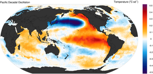


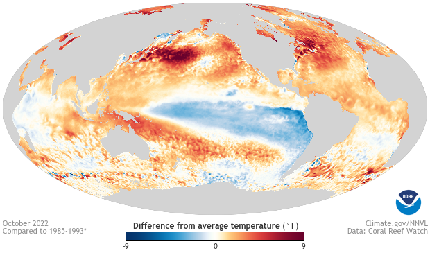
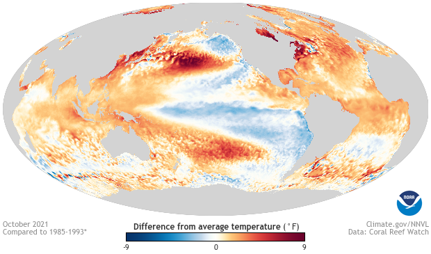
Above is an illustration of a positive phase of the PDO. I think of it in terms of red and blue Pacific horseshoes with red being the positive phase and blue (current phase) being negative. The more I continue to track SST anomaly configurations in the Pacific, the more I become dependent on its predictive value, but I also think it is important to take that deeper dive into SST conditions in the Pacific rather than just look at the actual PDO values themselves. This is where I think there is some encouraging news. Notice the cool water that was featured in the Gulf of Alaksa last autumn and this continued through much of last winter. This autumn we've seen warmer water in the Gulf of Alaska along with the continued warmth farther west near the IDL. The formation and sustainability of a jet stream ridge over Alaksa, a key driver of colder weather in North America is thus more likely this winter than last. At the same time however, there are similarities to the last few winters that will discourage favorable or unfavorable weather patterns from sustaining for more than a few weeks at a time. 


 Current Year SST Anomalies 
 

 Last Year SST Anomalies
 

 Snowcover Expansion

We saw a fairly typical expansion of snow and ice over the northern hemisphere this autumn. The Rutgers Snow Lab recorded 18.66 millions of sq. km in the month of October which is lower than the 10 year average, higher than the 30 year average and comparable to last winter. The 7.9 millions of sq. km recorded in the North American continent told a similar story. Arctic sea ice expansion has generally been materially higher than the record low values set a decade ago but the last few weeks have not been good with ice struggling fill in over the Chukchi Sea northwest of Alaska. Ice has expanded very rapidly over the Hudson Bay and is several weeks ahead of last year's pace which I see as encouraging. Very cold weather in northern Canada should help that freezing process along for the next week but some extreme jet stream blocking predicted to situate over the Davis Strait over the next few weeks might slow that process down. Overall, I don't see any reason to be particularly encouraged or discouraged by the expansion of snow cover or expansion of sea ice this winter. 


Weather Pattern Tells ? 

Lastly, I want to discuss whether the atmosphere has tipped its hand over the past several months in a way that might be a tell on what the weather pattern might do this winter. It's encouraging to see some split flow emerge in the Pacific defying what one might expect during a La Nina winter. If this is to continue, it would not only blunt the impact of any Pacific evil empire but produce a few southern streamers that could evolve into big east coast snow producers. Aside from that however I am discouraged with the warmer than normal four of the past five months (including November) over New England. Some of this can be attributed by the continued presence of warm water along the eastern seaboard and while this can help add fuel to big nor'easters (when we get them), the net impact of such a feature would be a warm one in the aggregate. I might add however that the water in coastal New England has cooled in the last few weeks and will not enter the winter with some of the excessive SST anomalies we saw last year. I recall observing areas of the western Atlantic that were 5-7 C above average and this year at the same point we are looking at some areas that are still +3 C. That said, when we see big warm surges with the excessive dewpoints on multiple occasions early this past November, it serves as a reminder of both the harsh impacts of La Nina (when the pattern isn't good) and the impact of warm water in the coastal Atlantic on the intensity of these tropical infusions.

Lovers of snowfall may have noticed that in recent years, the Alberta clipper has lost some potency across interior New England. We depend on snowfall from these type of disturbances and they are a big reason our snow climatology is what it is. During the last several years however, New England has seemingly been the destination of where clipper systems come to die. There's been speculation of this being attributed to longer term trends in weather or climate change and I would not want to dismiss that; in fact, I wouldn't dismiss any realistic hypothesis. My take and this is also just a hypothesis is that the recent lack of clipper potency is related to the aforementioned warm water near the New England coastline. Since we have cooled this water somewhat going into this season, I am curious to see whether the clipper can be at least somewhat revived.

Summary / Outlook

So my outlook looks as follows. There are too many similarities to the last several winters to deviate from a similar predicted result overall. We are going to need help at high latitudes to make up for sea surface temperature conditions that don't favor sustained cold and snowy weather in New England. Fortunately it does appear we will receive some of that in the form of a giant -NAO producing Greenland block in early December. This will help on the snowfall side of things though I am doubtful it will produce extreme cold. Much of that I think will be over the northeastern Eurasian peninsula. I am encouraged by the sea surface temperature changes in the Gulf of Alaska and the blunted SST warmth in the coastal Atlantic. I think this should produce a colder result in New England over the course of the next 4 months but I still think we will stay on the above side of average. Again we should see some big northeast storms, a few of which should impact interior New England quite favorably. I expect 1-2 good stretches of winter lasting a few weeks but once again, one has to anticipate some crushing blows and La Nina fueled inland runners that will eat away at our snowpack and deliver setbacks to the season. Temperatures overall 1-3 above average which is not at all excessive and snowfall a bit below average but within range of normal. On the snowfall side of things, I think we will beat last year's snow total with the combination of some big east coast storms and hopefully, a revived Clipper season. The latter might fall into the wishcasting category, but we will see. Happy to be back again folks and look forward to seeing everyone on the hill.


Monday, November 21, 2022

Pattern expected to relax a bit allowing for a post Thanksgiving warm-up but hope remains for early Dec !

A widespread outbreak of cold across the U.S. has been impressive in its expansiveness and its ability to produce the 6-7 feet of lake-effect snowfall in those climatologically favored areas just south of Buffalo. The snow band that set up over Watertown, NY was equally impressive and somewhat unusual because of the persistent impact north of the Tug Hill Forest/Plateau in towns such as Watertown eastward to the Five Ponds Wilderness area of the Adirondacks. Lake-effect snow hounds are used to seeing the Lake Ontario snowband set up in the area bound by the famous snow towns of Barnes Corners, NY to the north and Redfield, NY to the south. There was a lot of thunder reported with both snow bands illustrating how unstable the boundary layer of the lower troposphere was in this airmass. Water temperatures in the eastern Great Lakes have been in the upper 40's or even low 50's while temperatures 7,000 feet up were in the high teens. That will make for a very dynamic weather situation and it certainly did. 

Aside from the deep snow in some of those snow-belt regions we've seen a widespread outbreak of below normal temperatures. As I suspected, the Vermont high country has put together a nice consecutive stretch of sub-freezing weather conditions but it's not nearly enough to erase what was an historically warm start to the month of November (November is still likely to be substantially above normal). The western two thirds of the U.S. are experiencing a rather cool month however and this is driven by an EPO which started positive at the end of October, but has recently plummeted to an index of -4 just as Buffalo was getting clobbered with snow a few days ago.  One can think of the EPO as a measurement of jet stream activity in the Pacific and has proven to be a very useful indicator of weather over much of North America. This along with many of the other key teleconnection indices were quite favorable for winter weather this past week but will neutralize as we advance toward December. The EPO will remain marginally favorable and there suggestions in the ensemble data of more split flow type of activity which is very encouraging going into winter. At the same time we are expected to lose high latitude blocking support over the next two weeks. The jet stream is not expected to go entirely zonal but won't at all favor widespread below normal temperatures in eastern North America. The most discouraging indicator is the PNA which would suggest that cold and snow is more favored over western North America as the calendar turns to December. Most of the ensemble data was showing this through the weekend but backed off today and was suggesting that cool weather would linger over the northeast even as the west receives both snow and colder weather. Keep expectations in check in early December, it can be a disappointing time in Vermont and I think this year offers more hope than most. 

I am not especially excited about the potential storm after the Thanksgiving holiday. This should be a rain event with the cold having receded well before the advance of any precipitation with this system. The storm is also expected to amplify way too early leaving the only chance for frozen precipitation at the end of the event. I fully expect to keep our few inches of snow through Thanksgiving but not through the upcoming weekend. Seasonal outlook is a work in progress but it's coming. Thanks for the continued interest.

Monday, November 14, 2022

Pattern change set to bring immediate taste of winter to northern Vermont !

 Happy end to summer everyone ! We have begun the first 12 days of November warmer than how the last 12 days of September. We've had 2 rounds of excessive, tropical 60-degree dewpoint nights (at two different times), and much of Vermont has been warmer so far this November than most of northern California, and I am not talking about the mountains but low lying coastal areas and the interior semi-arid regions. Honestly, the quality of our weather this fall has been pretty darn good with an extended period of comfortable temperatures and lots of sunshine, but once the calendar turns to November, I'd rather talk about a different kind of weather. After all, we didn't choose to live in Vermont for 65-degree Thanksgivings and rain on Christmas although I've reached a point where the latter seems almost normal. 

Through almost half of November, much of northern Vermont is almost 15 degrees above normal but the month won't finish that way and the flakes of snow Monday morning marks the beginning of an extended and welcome stretch of early winter. There's a lot to talk about with Wednesday's winter storm (get to that in a second) but thinking about the big picture from the standpoint of snowmaking operations, much of the Vermont high country above 2000 feet will remain below freezing through at least Thanksgiving morning. That's the next 10 days and its November so we could certainly do a lot worse. 

The upcoming year will mark enough one without El Nino (more on that in the seasonal outlook coming in a week or so), but the upcoming storm looks like one that might occur in an El Nino year. After enduring a miserable angry Pacific Ocean jet stream, conditions have quickly shifted toward a split flow set up, a beautiful sight for northeast snow lovers. We wont' hold that for long but it will produce our midweek storm which will take shape in the Mississippi Delta region and proceed northeast. An enhanced area of low pressure along the Atlantic coast will form early Wednesday fueled largely by more anomalous sea surface temperature warmth along our coastline. What does this all mean ? Snow should begin after midnight and persist through much of Wednesday and into Wednesday evening. 

How much could fall ? Though I don't think we are walking a tightrope, we are bound by some early season constraints and the possibility that the coastal area of low pressure might stay east of Cape Cod. Regarding the latter, I think that's less likely and I prefer the scenario where we see some more aggressive intensification and a track west of Cape Cod. This will bring some heavy snowfall to northern Vermont Wednesday but this also threatens to allow intrusive layers of warm air turn precipitation to more of a mixed bag with consistency varying depending on elevation. Precipitation type in this case can also be highly dependent on how hard it is falling. Heavier precipitation falls as snow but lighter precipitation might fall as rain, sleet or freezing rain. Much of the high country could still be subject to some mixing but I really believe these areas will stay below freezing making this event a great base builder. Snowfall in valley locations should be pretty wet I think but some powdery snow is certainly possible above 2000 and especially 3000 feet. It's a whole different world up high ! 

Snow totals should be in the 3-6 inch category across valley areas and 6-12 in the high country. I wouldn't be afraid to forecast more aggressively if I wasn't worried about some mixing which has the potential to impact all elevations (even the ones that don't see above freezing temps). 

Though I don't see any organized weather system in the days following our Wednesday event, we are looking at an impressive stretch of cold. What an abrupt shift in the seasons  and even a small blanket of snow should 1) remain on the ground and 2) help overnight temperatures fall into the teens several highs prior to the Thanksgiving holiday. There are smaller disturbances indicated to offer the potential for light snow but before I start promising accumulations from clipper systems, I should remind readers that the "clipper" has been a meager performer the last few seasons and I have hypothesized that it is a function of the persistent warmth we've seen in coastal waters in the western Atlantic Ocean. This said, the warm water in Lake Champlain (51 degrees as of Monday), a direct consequence of all that early November warmth will produce some crazy thermals and very unstable boundary layers across the northern Green Mountains this weekend and early next week. There will be intervals of sunshine but there should be several opportunities for snow showers and snow squalls in this set up. Much of this activity will be focused on the area from Stowe northward to Jay Peak but if we can shift the winds more northwesterly, Mad River Glen and Sugarbush will see some of this as well. As far as temperatures are concerned, the Iphone is starting to spit out some days where temperatures don't reach 30 and I think that's right. One day this weekend and one day early next week are likely to see readings in the 20's and maybe even low 20's. 

Lastly, it is good to be back once again. I was flattered by the emails I received asking about the post season summary this past spring. I wasn't sure anyone even read those, but I do enjoy doing them. My day job usually gives me some downtime for adequate blog updates but this past April and May just got crazy and 10 minute tasks were taking 2 hours. I actually have the summary half written but just couldn't finish it given the vortex of work I was hit with. Regardless, the blog begins again for another season with a preseason outlook coming within a week or so. In the meantime enjoy our early taste of winter !


Tuesday, March 29, 2022

Milder weather, wind and some rain will quickly erase any recent snow Thursday, but we are reserving the right to one last possible wintry breath for 2nd weekend in April

Unless we see some indications of a major snow event, certainly not out of the realm of possibility, this will be my last regular post of the season. I certainly enjoy the annual review of the cold weather months and how it impacted our ski season in northern Vermont, so check back for that in a few weeks. The recent round of cold weather and snow was just enough to reinvigorate MRG for a a few turns on Sunday and the continued snow Monday into early Tuesday appears to have helped Sugarbush secure a few powdery days though it has been very windy. There are more indications of cool weather in very early April but nothing rivaling this 4-day encore of winter weather. It's not a difficult prognostication given the timing but this is very likely the last 3-4 day stretch of sub-freezing temperatures we see this season unless one can manage to keep their activities over 3,000 feet (in that case you might have a chance !). 

The short term 72-hour forecast appears to be a microcosm of the recent winter season. Following a decent round of cold weather and a dose of powder, ripping southerly winds on Thursday lay waste to a any recent snowfall and further erode lingering snowpack above 2000 feet. This all happens after a tranquil Wednesday with morning sunshine bathing northern Vermont and warming temperatures from the teens into the 30's. Some clouds late in the day might be followed by a round of mixed precipitation Wednesday evening before winds increase out of the south, sending temperatures well into the 50's across valley locations Thursday and 40's even at the highest elevations. The mild temperatures aren't necessarily the problem here, but the wind, higher dewpoints and some rain are certainly capable of sending the Vermont winter landscape further into memory. Winds will become westerly Friday and cooler temperatures will envelop the region for the first full weekend in April but I would not anticipate a full return to winter. Low level instability will favor elevation sensitive rain and snow showers but temperatures will remain close or even above the freezing mark during most of the period with the exception of the highest mountain summits. 

The early part of next week appears to favor the best chance for fair weather with sub-freezing overnights and 40's and 50's for daytime temperatures. During the later part of the week and extending into the weekend of April 9th and 10th, there have been indications of another push of milder weather that might quickly give way to a more amplified setup. Around the time of April 8th and 9th would be the potential time frame for what could be a east coast weather event of some significance including some spring winter weather in the mountains. If you are hoping for one last big storm, this could be our last shot for something with the ensembles making a move toward milder temperatures by April 11th.

Friday, March 25, 2022

Terrific setup for some intense snow showers Sunday into Monday across the MRV high country

Winter is poised to make a late March return to northern Vermont. Though the strength of the cold weather in the period between late Sunday and Tuesday is impressive, it is not atypical for interior New England to get bouts of January-like weather in early spring. March and April in Vermont can quite frequently feature the most volatile weather of the year and outcomes have ranged from near heat in 1998 or 2012 to intense cold like in 2011 or 2014 to big snow like we saw in March both in 2018 and 2019 (and plenty of other years). We've managed to mix it up pretty good this month and gone with the "all of the above" option, but with winter lined up for the final encore. 

The intense area of early spring cold air is poised to get infused into an impressively deep jet stream trough in eastern North America. Lingering relative warmth underneath this trough on Saturday is going to create a dynamic and convective setup across interior New England with any sunshine triggering instability clouds and a mixture of rain and snow showers. Valley locations can expect sprinkles and an occasional mixed rain/snow shower while the high country above 2000 feet will see some occasional heavier snow showers. The setup is certainly convective enough to produce graupel, a northern New England staple in early spring resulting from these type of setups. The MRV is actually not well positioned for Saturday's precipitation with the wind direction more westerly (favoring areas such as Jay Peak) while a disturbance passing to our south focuses showers on southern New England. This will change on Sunday as winds become northwesterly and low level cold arrives from Canada. Snow showers will be intermittent in valley locations but more persistent and occasionally heavy over the Vermont high country. It's worth reiterating how absent this has been from our recent winter season. Most of our snow deficit this year can be attributed to the lack of instability and terrain enhancement and specifically the inability of the weather pattern to produce a setup conducive for such. Sunday into Monday will feature the best conditions of the season for the very type of snowfall we have been missing. Though a rather innocuous 1-2 inch accumulation on grass can be expected in valley locations Sunday, 3-6 inches of mostly powder can be expected above 2000 feet and this snow will continue Sunday night into early Monday. Snow totals can be tricky to predict in these instances as some areas can get luckier than others based on where individual snow bands setup and exactly how the wind is blowing, but 6-12 inches is my guess for the MRV high country as a two-day total by late in the day Monday. 

Clouds will begin to decrease by later in the day Monday setting us up for single digit temperatures Monday night and a better visibility day on Tuesday. Monday will feature temperatures mainly in the teens which is over 20 degrees below normal. The sunshine on Tuesday will help boost readings into the 20's but above-freezing temps should hold off until Wednesday and perhaps even Thursday above 3000 feet. Both milder air and rain will put this wintry encore to bed late on Thursday into Friday but a second encore is not out of the question in early April. A rather persistent ridging feature above the Yukon is responsible for some of this and there is evidence of some split flow in the jet stream which could help give rise to more storminess in the first few days of April.

Sunday, March 20, 2022

Some cold weather and snow is likely to make a brief return to northern Vermont in a week, but only after another rain event late Wed/Thur

Hope everyone is enjoying or has enjoyed the last "offiical" day at MRG. I was certainly hoping to be able to report on a potential storm late this week, but that is not to be unfortunately. The pattern does appear quite capable of delivering a decent round of late March cold beginning around March 27th. A day late and a dollar short for the storm late this week but it would not be impossible to spin something up about a week from now.

 Temperatures have been running even warmer than my warm expectations the last several days but we still can expect a return to sub-freezing mountain weather both Sunday and Monday night (3/20-21). Snow showers appear likely Sunday night into early Monday but northwest flow at jet stream level should allow cloudiness to decrease as the day progresses leading to a chilly but clear Monday night and a bluebird type of Tuesday with just scattered fair weather clouds. We can probably squeeze another dry day out of Wednesday with temps starting near 20 and rising into the 40's. My disappointment relates to the storm late this week. I had hoped that a storm would bring 1-2 feet of powder to Colorado for my trip out there and then proceed to somehow do the same for Vermont and neither appears to be the case unless you are in the San Juan Mountains perhaps. This is another example of a strong system in the plains just getting too wound up too early and the cold weather we were hoping to infuse into this system getting delayed. It is thus a rainy outlook for us beginning Wednesday night and persisting into at least part of Thursday. 

Friday and Saturday appear drier and cooler but not cold with temperatures likely to remain above freezing except at the high summits. The cold weather arrives Sunday and with it comes a slight chance that a storm can quickly intensify along the New England coast. Models have been inconsistent on this idea the last few days but the Euro Ensemble showed the best signal yet this morning for a low pressure center bombing over the maritimes. We will need more than just a storm in the martimes for deep snow but we will have at least a few days of cold weather persisting into early next week (3/28 -29) before temperatures are indicated to moderate.  There is a deep enough trough associated with this cold air to allow for a healthy layer of low level instability and lots of snow showers even if a storm doesn't materialize. This is often the case in spring during cold weather outbreaks and I would be surprised if we don't see some accumulating snow during this period across the high country as a result

Even with operations suspended at MRG. I'll do a few more updates and then a season wrap-up.


Thursday, March 17, 2022

After an incredible St Paddy's day, we pay for it with a dark, gloomy, rainy Saturday, though outlook does look colder next week

St Patrick’s day 2022 turned into an absolute winner. An average March/April will have a few days like this sprinkled into the very gradual upward temperature slog, but I feel I should note how much I’ve come to appreciate the sun-decking weather at MRG with a full blast of March sunshine corning it up from top to bottom. Hopefully, many of you got a chance to get out and enjoy it and if not, Friday is a slightly cooler and somewhat cloudier version of Thursday with temperatures holding in the 50’s. The slightly cooler weather marks the advance of a weak low level push of cooler weather. Though the cooler air won’t be strong enough to put the corn horn away Friday, it seems intent on fouling up the weekend forecast. 

For as much as I love the weather on St Patrick’s day, I absolutely hate spring days like Saturday. That, aforementioned cooler air is strong enough to wedge itself into the interior New England mountains, keep temperatures across the high country in the high 30’s with little to no visibility. The cool air is not strong enough however to turn the rain to snow, and the wet weather will begin around dawn Saturday and continue sporadically throughout the day. Saturday gets a decided failing grade from me, but some classic New England payback for a perfect St Paddy’s day. As mentioned in the previous update, some cooler air aloft will begin to advance into Vermont Sunday but this will be a gradual process and I wouldn’t count on any snow; instead, we should see clouds and intervals of sunshine with temperatures reaching 50 in valley locations and 40’s on the mountain. 

Beyond Sunday the outlook does look colder and I think it will turn out somewhat wintry as well after we sort through all the details. Colder temperatures will settle over the region on Monday and it will remain unstable enough across the high country for some snow showers. It’s possible to see an accumulation, especially above 2000 feet but I wouldn’t guarantee that yet. Flurries will likely continue into Tuesday although it does appear we will see a bit more sun by then, Both Monday and Tuesday will see the return of some sub-freezing temps in the morning with readings climbing only slightly above freezing each afternoon. The most interesting weather feature over the next 2 weeks appears to be an event in the Thursday-Saturday time frame (March 24-26). We have a weak area of early spring cold air in eastern Canada and a much stronger dose of cold will be heading southeast in central Canada thanks to the formation of a small but notable jet stream block in the arctic, north of Alaska. At the same time, a weather feature should be advancing our way out of the southeast. In the aggregate, models aren’t screaming big storm, but some necessary ingredients appear to be in place for at least something. It will be certainly be worth watching models sort this whole situation out and it would be consistent with the up and down nature of this past winter season, to produce a big storm after another round of warmth. 

Expect cold weather to follow whatever kind of weather we get late next week and persist for several days into early in the following week, lets call it March 28th or so. The cool signal on the ensembles begins to fade after that as we advance toward April 1.