With all that said however, I am ready to take this whole thing off "blog.spot". If there are web development people that can help me do that, send me an email.
Another winter is upon us and yet another winter outlook leads the way. With that comes the usual disclaimer, proclaiming how utterly unreliable these long term outlooks are. I can actually claim to have graded out fairly decently on temperatures over the many years, but snowfall has been an up and down experience and I can promise that will continue. Adding to that disclaimer is the promise that if I truly find a reason to be pessimistic, it will be conveyed. Some sugarcoating can be expected because I like to keep conform to the optimistic prevailing tone of the blog but bad news is still important news and is always included on the blog, as uninvited as it certainly is.
ENSO/PDO
I am going to combine our yearly examination of ENSO (El Nino/La Nina) and Pacific Decadal Oscillation into one section this year. These two variables enjoy an imperfect relationship with each other, meaning that positive (El Nino) and negative (La Nina) ENSO events are usually associated with a PDO of a similar positive or negative sign. "Usually" however is not synomous with "always" and this appears to be one of those years, much like last year, where the signs will differ. Most importantly regarding El Nino, there were repeated (same as last year) fears that we were moving toward a more signifcant El Nino this autumn. Just like last year however, those fears have abated. SST's in those critical equatorial regions of the Pacific strengthened toward a moderate El Nino situation for a time but have weakened in recent weeks and forecasts going forward don't indicate that a big El Nino is unlikely. From our perspective that relagates ENSO to a more tertiary paramater in the equation though not a non-factor entirely.

Meanwhile the PDO, which appeared to be trending toward a positive phase earlier this year, has taken an autumnal plunge back into negative territory. The PDO describes the more general configuration of sea surface temperatures in the mid-latitude Pacific while ENSO refers to the region around the equator. Most interesting is the large red blob south of the Gulf of Alaska which appears to be the most dominant anomalous feature in the Pacific from a sea surface temperature standpoint.
So we have differing signs on the ENSO/PDO front, somewhat like what we had last year, which can be argued was one of the strongest Vermont ski seasons of the decade. When I saw this evolve, once again, it was my hope that I could glean a more clear cut cause and effect relationship from all this but saying that would be a reach. 1965-66, 1968-69, 1975-1976 and last year were all either very good or excellent snow years on the mountain. 1991-92 and 1994-95 were not. 4-2 isn't bad but not overwhelming. The large blog of SST warmth south of the Gulf of Alaska is probably the most disconcerting element of the outlook as a whole. It's stronger than the same feature last year and capable of tightening the Pacific Jet and limiting negative EPO episodes (such as the one we just experienced) and thus the amount of arctic air across mid-laititude North America. Later in the outlook, I will focus on a different but perhaps equally important SST feature that might counter that for the early part of the upcoming winter.

Chukchi Sea
From a bigger picture standpoint, the loss of sea ice is not in any way, a positive in the long term. It's hard to imagine the impact on our Nothern Hemisphere winter, as a whole if, 100 or so years from now, the arctic is struggling re-freeze as opposed the typical ritual of expanding to areas such as the Hudson Bay, the Bering Sea or the Baffin Bay. There can be little doubt we are headed in that direction. In the near term, it has been the Chukchi Sea which has raised some alarms this year because of the exceedingly slow rate of autumn ice expansion. Zack Labe is a terrific follow on twitter, handle -@Zlabe, for all things arctic sea ice. He and many others have been monitoring and reporting on the unprecented (in recorded history) sea ice situation in the Chukchi Sea which is a small subset of arctic water north of the Bering Straight but part of the larger Arctic Ocean. Though the loss of ice here underscores a larger overall (and not a good) trend regarding sea ice it has created a large area of warm ocean water in a key location. Can such a feature have an impact on the prevailing weather pattern by encouraging a high latitude jet stream block in such a location. If so, it would support some of the prevailing theories that exist regarding the effects of climate change in relation to redefining pathways of arctic cold and sustaining prevailing weather patterns for a longer duration than they might otherwise, both good and bad. I am not skeptical about the impacts of anomalous ocean water but I remain a little skeptical of statements such as the one I made above. I understand the logic certainly but would like to see more data.
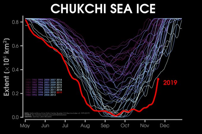
I understand there is a lot of overly scientific hypothesizing in the above two paragraphs. From the standpoint of our winter outlook, the expansion of snow and ice is obviosly a good thing for our winter , the Chukchi Sea ice anomaly certainly could be a good thing for our upcoming winter and this would counter the other large area of warm water south of the Gulf of Alaska which I do not consider to be such a good thing.
Atmospheric "Tells"
In a final bit of analysis, I would like to stay true to more recent tradition and spend some time discussing possible atmospheric "tells" - the phrase of course borrowed from common poker lingo. There has been quite a bit of anomalous weather over the past few months across North America, particularly anomalous cold. In October, a large area of anomalous cold focused itself over western North America and represented one of the largest areas of colder than average temperatures across the entire globe. In November, this area shifted eastward thanks largely to a very negative EPO (weakened Pacific Jet). Much of the Great Lakes region, eastward to Vermont are in the midst of one of the coldest November's ever recorded. It will likely fall short of the coldest thanks to a milder final 10 days of the month but could still be in the top 5 or 10 cold Novembers. What I find to be especially noteworthy is the intensity of the recent cold outbreaks, particularly the ability to reach daily anomalies of 25 and even 30 degree below normal over mid-latitude sections of North America. This first happened in the Rocky Mountain region in October and more recently over the Great Lakes in November. If the atmosphere is capable of aligning once to produce such outcomes it indicates the potential for a repeat later in the year. Were it not for the negative PDO and specifically some of the SST anomalies in the Pacific associated with it, I would probably be willing to go "all in" (more poker lingo) on a Polar Vortex style 1976-77 or 2013-2014 winter.

Summary/Outlook 2019-20
If you're smart and skipped down to this paragraph, well done ! Our little collection of variables that typically contribute to the winter outlook look, largely, very much the same as they did at this time last year. El Nino is present but, at the more preferable subdued intensity. We had a very healthy expansion of hemispheric land-area snow. We've been able to exhibit the ability to produce both sustained and intense periods of cold even early this season and I might mention that this rather impressive outbreak of November cold has helped to cool both the Great Lakes aggregate and the immediate waters off the northeast coast. Very much like last year, the Pacific Decadal Oscillation will enter the winter season in negative territory which is unique during any kind of El Nino, even the weaker variety. The nature of this particular negative PDO is the one big concern because the most prevalent associated feature is the aforementioned warm blob south of the Gulf of Alaska. So while I think the upcoming winter will exhibit some similarities to the very exciting 2018-19 season, we will experience 1-2 extended bouts of adverse conditions lasting a couple of weeks. But although the PDO is a net-negative as far as being a force for sustaining cold, it will keep the storm track from going too far south. This will, again make interior New England one of the more favored locations for heavy snows, at least along the east coast. This means another year of what I think will be above average snowfall and I have a funny feeling that a healthy chunk of that snowfall comes in the upcoming month of December (we will just see about that) ! Temperatures last year during the ski months averaged 2-3 degrees below average and we managed to freeze Lake Champlain for the third time this decade. In spite of one of the coldest November's since at least 1996, I don't think the upcoming winter will feature those kind of temperatures. Instead, I would expect temperatures closer to normal overall which means we are unlikely to see the sustained blowtorch conditions that we saw during the Super Nino of 2015-16 or the snow-torch winter that followed in 2016-17. With that, let the blogging efforts begin for another season, I hope it's a good one for everyone.

No comments:
Post a Comment