Winter arrived right on time across northern Vermont but it was nonetheless an abrupt shift from the torrent of tropical weather we saw in the period between late October and November 13. The winter weather and snowfall on November 16th forced the cart before horse as far as blogging efforts are concerned and you all are still owed a preseason outlook before we get too buried in specific outlooks. Speaking of debts, I am aware that the post season summary was never finished last year. I thought it might go unnoticed, but a few of you sent me some very nice reminders and it's nice to see even a few folks appreciate my efforts in creating the end of season summary. I still have a draft of the summary that was mostly finished, but day job responsibilities became so chaotic in April of this past year and 10 minute chores were taking 2 hours. You all know and understand how that is and things have settled down enough to allow blogging efforts to begin on time this winter season.
In the spirit of the World Cup which has commenced in Qatar, we are about to complete a full World Cup cycle of some similar early season conditions. I am not entirely happy about that as I would prefer to be staring a set of variables that might support a weather pattern capable of locking cold and snow across interior New England for a longer duration than a few weeks such was the case last year. Unfortunately and to pay homage to the Motown classic from the Four Tops, it's the same old song and i am hoping that a few subtle differences give a different meaning since to this winter than the last few.
ENSO
2022-23 will be the third consecutive winter we will be encountering a significant La Nina and it looks similar to the previous two seasons with ENSO conditions landing in what I would describe as the "moderate La Nina" category. La Nina's can be very good over interior New England and very typically the results are a lot better than areas farther south. When the pattern doesn't line up however, La Nina virtually guarantees New England some very intense pushes of mild air from the south and often times there can be several adverse events over a multi-week period that can put a major crimp in the snow season. Essentially, you need extra help from other causal variables that help determine a prevailing weather pattern. This has happened over the course of the last nearly 75 years of MRG existence. 3 of the greatest snow seasons ever recorded here, 1970-71, 2007-08 and 2010-11 all had the same preexisting conditions even beyond the state of the ENSO. Speaking probalistically however, it is a lot to ask of the weather pattern to deliver in this setup for more than few weeks at a time and this is exactly the obstacles that have confronted New England snow lovers the last few winter seasons. 2020-21 could have been one of those epic winters in Vermont since we had high latitude blocking help for much of February, but the storm track shifted too far south and we were left in a unlucky geographical location. Last year we had 4 really good weeks and landed ourselves in the sweet spot for 2 storms, but the pattern wasn't capable of supporting winter weather for more than a month and much of both December, the last 2/3 of February and March were a struggle.
I added last year to the chart which tracks the ENSO and PDO over the last several seasons. Not difficult to see the similarities to last year.
PDO
From ENSO we move to the Pacific Decadal Oscillation or PDO which, as I've mentioned a few times has some relationship to the ENSO though not perfect. La Nina winters tend to be associated with negative PDO mid-latitude Pacific SST conditions while El Nino's tend to have positive PDO SST conditions. We've basically been stuck with a negative PDO for what will be the 5th consecutive winter. A positive PDO is not a requirement for a healthy snow year in Vermont along with sustained cold weather but I do prefer it given the choice. We saw a record snow year (focused more in southern New England) with the extreme positive PDO values we saw in the 2014-2015 winter but the Super Nino winter of 2015-16 also saw some strong positive PDO values in a absolutely abysmal snow year in Vermont. What tends to bother me about negative PDO winters is the inability to lock a favorable winter weather pattern into New England for more than a few weeks at a time and I can expand on this more in the next paragraph.
Positive PDO Phase
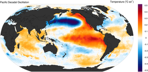
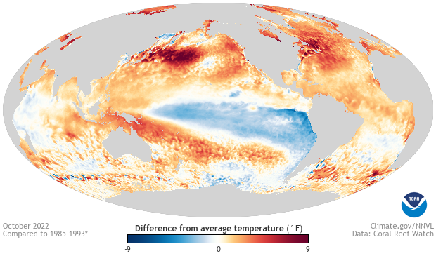
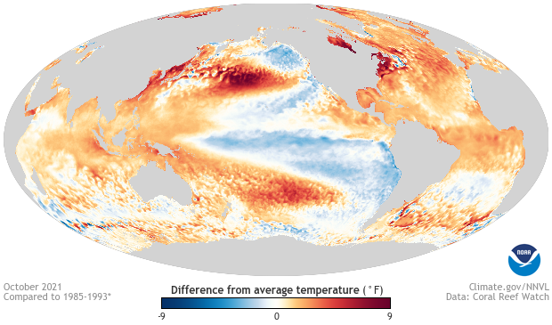
Above is an illustration of a positive phase of the PDO. I think of it in terms of red and blue Pacific horseshoes with red being the positive phase and blue (current phase) being negative. The more I continue to track SST anomaly configurations in the Pacific, the more I become dependent on its predictive value, but I also think it is important to take that deeper dive into SST conditions in the Pacific rather than just look at the actual PDO values themselves. This is where I think there is some encouraging news. Notice the cool water that was featured in the Gulf of Alaksa last autumn and this continued through much of last winter. This autumn we've seen warmer water in the Gulf of Alaska along with the continued warmth farther west near the IDL. The formation and sustainability of a jet stream ridge over Alaksa, a key driver of colder weather in North America is thus more likely this winter than last. At the same time however, there are similarities to the last few winters that will discourage favorable or unfavorable weather patterns from sustaining for more than a few weeks at a time.
Current Year SST Anomalies
Last Year SST Anomalies
Snowcover Expansion
We saw a fairly typical expansion of snow and ice over the northern hemisphere this autumn. The Rutgers Snow Lab recorded 18.66 millions of sq. km in the month of October which is lower than the 10 year average, higher than the 30 year average and comparable to last winter. The 7.9 millions of sq. km recorded in the North American continent told a similar story. Arctic sea ice expansion has generally been materially higher than the record low values set a decade ago but the last few weeks have not been good with ice struggling fill in over the Chukchi Sea northwest of Alaska. Ice has expanded very rapidly over the Hudson Bay and is several weeks ahead of last year's pace which I see as encouraging. Very cold weather in northern Canada should help that freezing process along for the next week but some extreme jet stream blocking predicted to situate over the Davis Strait over the next few weeks might slow that process down. Overall, I don't see any reason to be particularly encouraged or discouraged by the expansion of snow cover or expansion of sea ice this winter.


Weather Pattern Tells ?
Lastly, I want to discuss whether the atmosphere has tipped its hand over the past several months in a way that might be a tell on what the weather pattern might do this winter. It's encouraging to see some split flow emerge in the Pacific defying what one might expect during a La Nina winter. If this is to continue, it would not only blunt the impact of any Pacific evil empire but produce a few southern streamers that could evolve into big east coast snow producers. Aside from that however I am discouraged with the warmer than normal four of the past five months (including November) over New England. Some of this can be attributed by the continued presence of warm water along the eastern seaboard and while this can help add fuel to big nor'easters (when we get them), the net impact of such a feature would be a warm one in the aggregate. I might add however that the water in coastal New England has cooled in the last few weeks and will not enter the winter with some of the excessive SST anomalies we saw last year. I recall observing areas of the western Atlantic that were 5-7 C above average and this year at the same point we are looking at some areas that are still +3 C. That said, when we see big warm surges with the excessive dewpoints on multiple occasions early this past November, it serves as a reminder of both the harsh impacts of La Nina (when the pattern isn't good) and the impact of warm water in the coastal Atlantic on the intensity of these tropical infusions.
Lovers of snowfall may have noticed that in recent years, the Alberta clipper has lost some potency across interior New England. We depend on snowfall from these type of disturbances and they are a big reason our snow climatology is what it is. During the last several years however, New England has seemingly been the destination of where clipper systems come to die. There's been speculation of this being attributed to longer term trends in weather or climate change and I would not want to dismiss that; in fact, I wouldn't dismiss any realistic hypothesis. My take and this is also just a hypothesis is that the recent lack of clipper potency is related to the aforementioned warm water near the New England coastline. Since we have cooled this water somewhat going into this season, I am curious to see whether the clipper can be at least somewhat revived.
Summary / Outlook
So my outlook looks as follows. There are too many similarities to the last several winters to deviate from a similar predicted result overall. We are going to need help at high latitudes to make up for sea surface temperature conditions that don't favor sustained cold and snowy weather in New England. Fortunately it does appear we will receive some of that in the form of a giant -NAO producing Greenland block in early December. This will help on the snowfall side of things though I am doubtful it will produce extreme cold. Much of that I think will be over the northeastern Eurasian peninsula. I am encouraged by the sea surface temperature changes in the Gulf of Alaska and the blunted SST warmth in the coastal Atlantic. I think this should produce a colder result in New England over the course of the next 4 months but I still think we will stay on the above side of average. Again we should see some big northeast storms, a few of which should impact interior New England quite favorably. I expect 1-2 good stretches of winter lasting a few weeks but once again, one has to anticipate some crushing blows and La Nina fueled inland runners that will eat away at our snowpack and deliver setbacks to the season. Temperatures overall 1-3 above average which is not at all excessive and snowfall a bit below average but within range of normal. On the snowfall side of things, I think we will beat last year's snow total with the combination of some big east coast storms and hopefully, a revived Clipper season. The latter might fall into the wishcasting category, but we will see. Happy to be back again folks and look forward to seeing everyone on the hill.

1 comment:
Thanks for the summary/update! I am one of the many people who look forward to these and really enjoy your posts. Please keep them coming if time allows!
Post a Comment