No need to beat around the bush with a big storm bearing down the east coast. By now, I had hoped we would have reached some sort of decisiveness regarding this event but for now, it remains very much on the fence between a garden variety, easily forgotten weather system and a more memorable early December winter storm. The pieces are coming together as expected with the storm, as of Saturday, spinning its way through the upper Midwest. The emergence of a coastal low pressure center by Sunday evening will ultimately make this a big east coast precipitation producer but the track of this coastal system is expected to stay south of Long Island and south of Cape Cod, at least for the time being. This would keep the heaviest zone of snow south of the northern half of Vermont, especially since the well-established jet stream level support for this storm, otherwise referred to as an upper level low, is expected to move due east and take the east coast "escape hatch" out over the Delmarva. This feature is then expected to take a turn northeastward but it would be too late for the Mad River Valley to procure an epic snow event; instead, it would be a smaller event. It is very close however and between Friday afternoon and Saturday afternoon, models have been suggesting that the zone of best snow would be a little farther north. Southern Vermont is in fact in one of those "best zone" areas and if the storm would track another 50 miles farther north, it could really turn the outcome. So I can throw out some expectations as it stands now and simply throw it out there that things could certainly change for the better.
So with the big picture situation established the particulars are as follows. Snow should begin Sunday evening and fall moderately for a time before midnight. As the coastal low pressure center intensifies and assuming it tracks as predicted, the precipitation will consolidate over southern and central New England and the snow will dissipate somewhat over northern Vermont. By Monday morning, the zone of heaviest snow is expected to be situated over the Catskills, extreme NE Pennsylvania and eventually extending into southeast New Jersey. As both the surface and upper level features associated with this big east coast storm move northeast, the heavier snow will also push northeastward and again impact much of Vermont, especially the southern half of the state. Mad River Glen will get some of this as well with the heaviest snow falling Monday afternoon and evening. Total snowfall with this storm track is likely to be in the 8-16 inch territory. Snowfall totals could reach two feet over the high country of southern Vermont and certainly over the Catskills of New York state. The intensity of the storm will certainly allow for very blustery conditions through Tuesday.
Sub-freezing temperatures are expected to continue for the balance of the week but significant snow is unlikely. Flurries are expected to continue through Tuesday and weather disturbance passing to the region's south will spread some snow showers into the state Wednesday night and those will continue into Thursday. A more intense shot of arctic chill is expected to arrive Friday evening and with that could come some more light snow or snow showers through early Saturday.
The longer range outlook, beyond next weekend looks more mediocre as of now. The two most glaring things is the lack of high latitude blocking quantified by a rising AO index. The EPO, which for much of November remained largely negative and was defined by a loose Pacific Jet, will neutralize, allowing the Pacific jet to become more active. These two changes will limit the influence of arctic cold in mid-latitude North America. That said, there are no indications we are moving into full blown "el torchy" mode. I would expect 2-3 fairly mild days between December 8th and 18th which is not atypical in a Vermont December. The pattern also continues to look stormy and snowfall will thus remain a possibility in spite of a more zonal jet stream pattern.
Saturday, November 30, 2019
Tuesday, November 26, 2019
Upcoming week is very active and December 1st and 2nd looks especially interesting
With the seasonal outlook delivered, it is time to quickly shift gears and talk about what is an active looking week of weather even if it's not especially cold. We are about to finish the coldest November so far this century, colder even than last year's Snowvember. Much of the arctic air responsible for this very cold month has retreated an active jet stream is poised to deliver two major weather systems to the east coast, both of which are likely to be elevation sensitive but significant events - especially #2.
The storm responsible for over a foot of snow early Tuesday over portions of the Colorado front range will move northeast toward the eastern Great Lakes bringing a push of milder temperatures up the eastern seaboard. For a time, this milder air appeared also headed for Vermont but a re-aligning polar jet stream in Canada will help turn this storm eastward preventing the state from getting blow-torched. It will be warm enough for precipitation to begin as rain up and down many of the green mountains, even at the highest elevations but as we head toward the evening precipitation will begin changing to snow at the summits. During the overnight hours, we should see some snow even in the lower valleys while the ski areas receive 4-8 inches. Light snow should persist over the high country for a decent portion of Thanksgiving day as well with temperatures just below the freezing mark. This basically means that much of what falls Wednesday night into Thanksgiving Day will be pretty wet, except above at least 3000 feet.
A moderated polar air mass will build across the state late Thursday into Friday drying it out and providing a couple of days of sunshine both Friday and Saturday. Friday will be a bit on the blustery side, Saturday will be relatively calm. Both days should feature temperatures below the freezing mark throughout the day.
While the Thanksgiving event was a storm that originated in the southern Rockies, the storm poised to impact the east coast in the Dec 1-3 time frame is a powerful area of jet energy that will slowly migrate its way into California in the coming days, bringing heavy snow to a huge swath of heavy snow to a broad area of western ski country (both north and south) and proceed into the northern plains this upcoming weekend. Under many circumstances the storm would become a spent force while occluding across the north-central part of the country but the jet stream is poised to re-amplify across the east coast setting the east coast snowfall potential through the roof. The fresh supply of cold air is somewhat lacking, as it often is in early December, but the interior high country is positioned extremely well for a very big event given the right track. We've seen some good consistency from the European model the last several runs which makes me extremely optimistic. The Canadian model is also on board as of midday Tuesday but the American did shift the track of this storm pretty far south. In any case, the event remains 5-6 days off so we can't quite lock it in yet.
Normal early December temperatures will follow in the wake of this storm, whether we get the full impact or not. Some light snow is again possible later in that week.
Glancing toward the middle of December, the pattern does not appear arctic but not torchy either. A positive Arctic Oscillation is likely to keep wintry weather combined to Canada and the far northern latitudes of the US. Fortunately Vermont makes the cut there so wintry conditions remain possible through the 15th .
Monday, November 25, 2019
Can't really complain if we get more of the same ! Winter 2019-20 has many of the same 2018-19 characteristics
2019-2020 marks the 16th year of weather blogging for Mad River Glen, a sweet sixteen of sorts. Though I am proud of the duration, what is more remarkable is taking a step back to realize all the changes that have occurred relating to weather dissemination online. Back in 2004 it was a new thing, now it is a very "evolved" thing. Raw data is more readily available, model data has improved and become more readily available, many amateur weather fanatics have fined tune their skill sets and have become excellent resources (some have not but I like to keep it positive) and social media happened and it really became crazy. Yet our beloved weather blog stays mostly the same again, retaining its look and format much like Mad River Glen, a place that truly does skiing justice by staying true to its best traditions.
With all that said however, I am ready to take this whole thing off "blog.spot". If there are web development people that can help me do that, send me an email.
Another winter is upon us and yet another winter outlook leads the way. With that comes the usual disclaimer, proclaiming how utterly unreliable these long term outlooks are. I can actually claim to have graded out fairly decently on temperatures over the many years, but snowfall has been an up and down experience and I can promise that will continue. Adding to that disclaimer is the promise that if I truly find a reason to be pessimistic, it will be conveyed. Some sugarcoating can be expected because I like to keep conform to the optimistic prevailing tone of the blog but bad news is still important news and is always included on the blog, as uninvited as it certainly is.
ENSO/PDO
I am going to combine our yearly examination of ENSO (El Nino/La Nina) and Pacific Decadal Oscillation into one section this year. These two variables enjoy an imperfect relationship with each other, meaning that positive (El Nino) and negative (La Nina) ENSO events are usually associated with a PDO of a similar positive or negative sign. "Usually" however is not synomous with "always" and this appears to be one of those years, much like last year, where the signs will differ. Most importantly regarding El Nino, there were repeated (same as last year) fears that we were moving toward a more signifcant El Nino this autumn. Just like last year however, those fears have abated. SST's in those critical equatorial regions of the Pacific strengthened toward a moderate El Nino situation for a time but have weakened in recent weeks and forecasts going forward don't indicate that a big El Nino is unlikely. From our perspective that relagates ENSO to a more tertiary paramater in the equation though not a non-factor entirely.

Meanwhile the PDO, which appeared to be trending toward a positive phase earlier this year, has taken an autumnal plunge back into negative territory. The PDO describes the more general configuration of sea surface temperatures in the mid-latitude Pacific while ENSO refers to the region around the equator. Most interesting is the large red blob south of the Gulf of Alaska which appears to be the most dominant anomalous feature in the Pacific from a sea surface temperature standpoint.
So we have differing signs on the ENSO/PDO front, somewhat like what we had last year, which can be argued was one of the strongest Vermont ski seasons of the decade. When I saw this evolve, once again, it was my hope that I could glean a more clear cut cause and effect relationship from all this but saying that would be a reach. 1965-66, 1968-69, 1975-1976 and last year were all either very good or excellent snow years on the mountain. 1991-92 and 1994-95 were not. 4-2 isn't bad but not overwhelming. The large blog of SST warmth south of the Gulf of Alaska is probably the most disconcerting element of the outlook as a whole. It's stronger than the same feature last year and capable of tightening the Pacific Jet and limiting negative EPO episodes (such as the one we just experienced) and thus the amount of arctic air across mid-laititude North America. Later in the outlook, I will focus on a different but perhaps equally important SST feature that might counter that for the early part of the upcoming winter.
 Land Area Snow Expansion
The expansion of snowcover has been very impressive once again in October across the northern latitudes. The arctic has made a lot of news, as well it should, for the dwindling amounts of sea ice that have been observed late in the summer or early in the autumn, and the impact that it's had on various, though sparsely populated climate zones. In this analysis, we are looking more specifically at land areas and how snowcover is differing from the near 50-year mean. So while sea ice continues to make news by continuing to melt away, the last 7 October's have featured a very strong expansion of snow cover, 3 of which, including this most recent October, have been over a full standard deviation above this 50 year mean of 18.51 millions of square KM. There are obvious limitations to a 50-year data set but the recent trends certainly begs the question of how might the expansion of open water in the arctic be impacting this data. I am no climatologist and would not pretend to be able to answer this question better than some, but at this point I have to guess that there is an impact. Keeping our proverbial eye on the ball however, the rapid expansion of snow cover this October is a positive as far as cold air "pooling efficiency" is concerned and would suggest that arctic air will be a powerful ally this winter, as it was for much of the winter last year, even when the overall jet stream pattern was not.
Chukchi Sea
From a bigger picture standpoint, the loss of sea ice is not in any way, a positive in the long term. It's hard to imagine the impact on our Nothern Hemisphere winter, as a whole if, 100 or so years from now, the arctic is struggling re-freeze as opposed the typical ritual of expanding to areas such as the Hudson Bay, the Bering Sea or the Baffin Bay. There can be little doubt we are headed in that direction. In the near term, it has been the Chukchi Sea which has raised some alarms this year because of the exceedingly slow rate of autumn ice expansion. Zack Labe is a terrific follow on twitter, handle -@Zlabe, for all things arctic sea ice. He and many others have been monitoring and reporting on the unprecented (in recorded history) sea ice situation in the Chukchi Sea which is a small subset of arctic water north of the Bering Straight but part of the larger Arctic Ocean. Though the loss of ice here underscores a larger overall (and not a good) trend regarding sea ice it has created a large area of warm ocean water in a key location. Can such a feature have an impact on the prevailing weather pattern by encouraging a high latitude jet stream block in such a location. If so, it would support some of the prevailing theories that exist regarding the effects of climate change in relation to redefining pathways of arctic cold and sustaining prevailing weather patterns for a longer duration than they might otherwise, both good and bad. I am not skeptical about the impacts of anomalous ocean water but I remain a little skeptical of statements such as the one I made above. I understand the logic certainly but would like to see more data.
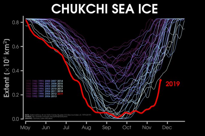
I understand there is a lot of overly scientific hypothesizing in the above two paragraphs. From the standpoint of our winter outlook, the expansion of snow and ice is obviosly a good thing for our winter , the Chukchi Sea ice anomaly certainly could be a good thing for our upcoming winter and this would counter the other large area of warm water south of the Gulf of Alaska which I do not consider to be such a good thing.
Atmospheric "Tells"
In a final bit of analysis, I would like to stay true to more recent tradition and spend some time discussing possible atmospheric "tells" - the phrase of course borrowed from common poker lingo. There has been quite a bit of anomalous weather over the past few months across North America, particularly anomalous cold. In October, a large area of anomalous cold focused itself over western North America and represented one of the largest areas of colder than average temperatures across the entire globe. In November, this area shifted eastward thanks largely to a very negative EPO (weakened Pacific Jet). Much of the Great Lakes region, eastward to Vermont are in the midst of one of the coldest November's ever recorded. It will likely fall short of the coldest thanks to a milder final 10 days of the month but could still be in the top 5 or 10 cold Novembers. What I find to be especially noteworthy is the intensity of the recent cold outbreaks, particularly the ability to reach daily anomalies of 25 and even 30 degree below normal over mid-latitude sections of North America. This first happened in the Rocky Mountain region in October and more recently over the Great Lakes in November. If the atmosphere is capable of aligning once to produce such outcomes it indicates the potential for a repeat later in the year. Were it not for the negative PDO and specifically some of the SST anomalies in the Pacific associated with it, I would probably be willing to go "all in" (more poker lingo) on a Polar Vortex style 1976-77 or 2013-2014 winter.

Summary/Outlook 2019-20
If you're smart and skipped down to this paragraph, well done ! Our little collection of variables that typically contribute to the winter outlook look, largely, very much the same as they did at this time last year. El Nino is present but, at the more preferable subdued intensity. We had a very healthy expansion of hemispheric land-area snow. We've been able to exhibit the ability to produce both sustained and intense periods of cold even early this season and I might mention that this rather impressive outbreak of November cold has helped to cool both the Great Lakes aggregate and the immediate waters off the northeast coast. Very much like last year, the Pacific Decadal Oscillation will enter the winter season in negative territory which is unique during any kind of El Nino, even the weaker variety. The nature of this particular negative PDO is the one big concern because the most prevalent associated feature is the aforementioned warm blob south of the Gulf of Alaska. So while I think the upcoming winter will exhibit some similarities to the very exciting 2018-19 season, we will experience 1-2 extended bouts of adverse conditions lasting a couple of weeks. But although the PDO is a net-negative as far as being a force for sustaining cold, it will keep the storm track from going too far south. This will, again make interior New England one of the more favored locations for heavy snows, at least along the east coast. This means another year of what I think will be above average snowfall and I have a funny feeling that a healthy chunk of that snowfall comes in the upcoming month of December (we will just see about that) ! Temperatures last year during the ski months averaged 2-3 degrees below average and we managed to freeze Lake Champlain for the third time this decade. In spite of one of the coldest November's since at least 1996, I don't think the upcoming winter will feature those kind of temperatures. Instead, I would expect temperatures closer to normal overall which means we are unlikely to see the sustained blowtorch conditions that we saw during the Super Nino of 2015-16 or the snow-torch winter that followed in 2016-17. With that, let the blogging efforts begin for another season, I hope it's a good one for everyone.
With all that said however, I am ready to take this whole thing off "blog.spot". If there are web development people that can help me do that, send me an email.
Another winter is upon us and yet another winter outlook leads the way. With that comes the usual disclaimer, proclaiming how utterly unreliable these long term outlooks are. I can actually claim to have graded out fairly decently on temperatures over the many years, but snowfall has been an up and down experience and I can promise that will continue. Adding to that disclaimer is the promise that if I truly find a reason to be pessimistic, it will be conveyed. Some sugarcoating can be expected because I like to keep conform to the optimistic prevailing tone of the blog but bad news is still important news and is always included on the blog, as uninvited as it certainly is.
ENSO/PDO
I am going to combine our yearly examination of ENSO (El Nino/La Nina) and Pacific Decadal Oscillation into one section this year. These two variables enjoy an imperfect relationship with each other, meaning that positive (El Nino) and negative (La Nina) ENSO events are usually associated with a PDO of a similar positive or negative sign. "Usually" however is not synomous with "always" and this appears to be one of those years, much like last year, where the signs will differ. Most importantly regarding El Nino, there were repeated (same as last year) fears that we were moving toward a more signifcant El Nino this autumn. Just like last year however, those fears have abated. SST's in those critical equatorial regions of the Pacific strengthened toward a moderate El Nino situation for a time but have weakened in recent weeks and forecasts going forward don't indicate that a big El Nino is unlikely. From our perspective that relagates ENSO to a more tertiary paramater in the equation though not a non-factor entirely.

Meanwhile the PDO, which appeared to be trending toward a positive phase earlier this year, has taken an autumnal plunge back into negative territory. The PDO describes the more general configuration of sea surface temperatures in the mid-latitude Pacific while ENSO refers to the region around the equator. Most interesting is the large red blob south of the Gulf of Alaska which appears to be the most dominant anomalous feature in the Pacific from a sea surface temperature standpoint.
So we have differing signs on the ENSO/PDO front, somewhat like what we had last year, which can be argued was one of the strongest Vermont ski seasons of the decade. When I saw this evolve, once again, it was my hope that I could glean a more clear cut cause and effect relationship from all this but saying that would be a reach. 1965-66, 1968-69, 1975-1976 and last year were all either very good or excellent snow years on the mountain. 1991-92 and 1994-95 were not. 4-2 isn't bad but not overwhelming. The large blog of SST warmth south of the Gulf of Alaska is probably the most disconcerting element of the outlook as a whole. It's stronger than the same feature last year and capable of tightening the Pacific Jet and limiting negative EPO episodes (such as the one we just experienced) and thus the amount of arctic air across mid-laititude North America. Later in the outlook, I will focus on a different but perhaps equally important SST feature that might counter that for the early part of the upcoming winter.

Chukchi Sea
From a bigger picture standpoint, the loss of sea ice is not in any way, a positive in the long term. It's hard to imagine the impact on our Nothern Hemisphere winter, as a whole if, 100 or so years from now, the arctic is struggling re-freeze as opposed the typical ritual of expanding to areas such as the Hudson Bay, the Bering Sea or the Baffin Bay. There can be little doubt we are headed in that direction. In the near term, it has been the Chukchi Sea which has raised some alarms this year because of the exceedingly slow rate of autumn ice expansion. Zack Labe is a terrific follow on twitter, handle -@Zlabe, for all things arctic sea ice. He and many others have been monitoring and reporting on the unprecented (in recorded history) sea ice situation in the Chukchi Sea which is a small subset of arctic water north of the Bering Straight but part of the larger Arctic Ocean. Though the loss of ice here underscores a larger overall (and not a good) trend regarding sea ice it has created a large area of warm ocean water in a key location. Can such a feature have an impact on the prevailing weather pattern by encouraging a high latitude jet stream block in such a location. If so, it would support some of the prevailing theories that exist regarding the effects of climate change in relation to redefining pathways of arctic cold and sustaining prevailing weather patterns for a longer duration than they might otherwise, both good and bad. I am not skeptical about the impacts of anomalous ocean water but I remain a little skeptical of statements such as the one I made above. I understand the logic certainly but would like to see more data.
I understand there is a lot of overly scientific hypothesizing in the above two paragraphs. From the standpoint of our winter outlook, the expansion of snow and ice is obviosly a good thing for our winter , the Chukchi Sea ice anomaly certainly could be a good thing for our upcoming winter and this would counter the other large area of warm water south of the Gulf of Alaska which I do not consider to be such a good thing.
Atmospheric "Tells"
In a final bit of analysis, I would like to stay true to more recent tradition and spend some time discussing possible atmospheric "tells" - the phrase of course borrowed from common poker lingo. There has been quite a bit of anomalous weather over the past few months across North America, particularly anomalous cold. In October, a large area of anomalous cold focused itself over western North America and represented one of the largest areas of colder than average temperatures across the entire globe. In November, this area shifted eastward thanks largely to a very negative EPO (weakened Pacific Jet). Much of the Great Lakes region, eastward to Vermont are in the midst of one of the coldest November's ever recorded. It will likely fall short of the coldest thanks to a milder final 10 days of the month but could still be in the top 5 or 10 cold Novembers. What I find to be especially noteworthy is the intensity of the recent cold outbreaks, particularly the ability to reach daily anomalies of 25 and even 30 degree below normal over mid-latitude sections of North America. This first happened in the Rocky Mountain region in October and more recently over the Great Lakes in November. If the atmosphere is capable of aligning once to produce such outcomes it indicates the potential for a repeat later in the year. Were it not for the negative PDO and specifically some of the SST anomalies in the Pacific associated with it, I would probably be willing to go "all in" (more poker lingo) on a Polar Vortex style 1976-77 or 2013-2014 winter.
Summary/Outlook 2019-20
If you're smart and skipped down to this paragraph, well done ! Our little collection of variables that typically contribute to the winter outlook look, largely, very much the same as they did at this time last year. El Nino is present but, at the more preferable subdued intensity. We had a very healthy expansion of hemispheric land-area snow. We've been able to exhibit the ability to produce both sustained and intense periods of cold even early this season and I might mention that this rather impressive outbreak of November cold has helped to cool both the Great Lakes aggregate and the immediate waters off the northeast coast. Very much like last year, the Pacific Decadal Oscillation will enter the winter season in negative territory which is unique during any kind of El Nino, even the weaker variety. The nature of this particular negative PDO is the one big concern because the most prevalent associated feature is the aforementioned warm blob south of the Gulf of Alaska. So while I think the upcoming winter will exhibit some similarities to the very exciting 2018-19 season, we will experience 1-2 extended bouts of adverse conditions lasting a couple of weeks. But although the PDO is a net-negative as far as being a force for sustaining cold, it will keep the storm track from going too far south. This will, again make interior New England one of the more favored locations for heavy snows, at least along the east coast. This means another year of what I think will be above average snowfall and I have a funny feeling that a healthy chunk of that snowfall comes in the upcoming month of December (we will just see about that) ! Temperatures last year during the ski months averaged 2-3 degrees below average and we managed to freeze Lake Champlain for the third time this decade. In spite of one of the coldest November's since at least 1996, I don't think the upcoming winter will feature those kind of temperatures. Instead, I would expect temperatures closer to normal overall which means we are unlikely to see the sustained blowtorch conditions that we saw during the Super Nino of 2015-16 or the snow-torch winter that followed in 2016-17. With that, let the blogging efforts begin for another season, I hope it's a good one for everyone.
Tuesday, April 30, 2019
2018-2019 relived - It was great to be a northern Vermonter !!
Following several years of mixed to flat-out bad snow seasons, Mad River Glen finally procured a truly great one. Yes, we did a few crusty interludes but even the best ski seasons in New England feature a bit of that. The thaws were short-lived and northern New England fended off some of the adverse weather patterns quite admirably and performed exceptionally well as a whole when the pattern supported either marginal or favorable stretches of wintry weather in eastern North America. Going into the month of March, one might have been a bit ambivolent as to how to categorize the snow season, but once again, the mountain was able to procure a massive March snow event of nearly 3-feet, the third consecutive season with such a result. This brought the seasonal snow totals and the total base to some of the best levels of the decade. It was an even better year to our north, where the snow at the Mt Mansfield stake nearly reached the highest level ever recorded. Overall however, northern Vermont was a favored location this season which was a reversal from the season prior when southern Vermont recorded above normal snowfall but northern Vermont was just below.
Below is a link to the Mt Mansfield data which is cleaned up nicely by our friend Matt Parrilla
Mt Mansfield Snow Stake
And following another dose of spring snow. Here are some selected seasonal snowfall total amounts for random ski areas mostly inside a Vermont, but a few outside as well.
Jay Peak.... 423"
Smuggs....387"
Stowe.....311"
Mad River Glen....244"
Sugarbush....239"
Killington....223"
Stratton....137"
Mt Snow....140"
Hunter Mt, NY....71"
Camelback, PA....43"
Though a good snow season was predicted by the SCWB and a few others, it didn't arrive without concerns. The previous summer featured invariable heat and humidity over New England that I attributed to an area of sea surface temperature warmth off the New England coast. Additionally, we had a strengthening El Nino that was much weaker than the one in 2015-16, but was nonetheless threatening to become a more detrimental force in the regions weather with further intensification. The Pacific Decadal Oscillation (PDO) which had provided the region with consecutive years of favorable support had largely neutralized itself by the fall. All that said, the pattern had clearly turned away from "warm" and had done so quite abrupty around the time of October 12th. Within a month, the warm sea surface temperature blob off the New England coast had vanished and a healthy build-up of snow across the northern hemisphere hinted that colder weather would indeed prove to be formidable during the winter and it was.
Following some elevation snow events in late October, more widespread snow accumulation began around the time of November 10th along with a friendly stretch of cold weather. A large east coast storm on November 15-16, the biggest of the season in several areas along the coast, deposited upwards of a foot of snow across ski country and this was followed by additional snows in the days leading up to Thanksgiving. Incredibly, conditions at Sugarbush on the celebrated third Thursday of November could have been confused with what one might expect in January. I mean let's be real, many January and the last two February's have been considerably worse. Thanksgiving even featured January-like temperatures including a sub-zero morning and only teens in the afternoon. The clammer to open Mad River Glen appeared to be growing by the day and being the "people pleasers" that they are, the staff got it done and opened on Friday, November 24th, day 1 of 136 !!! The earliest open I can remember in the coop era.
And then November 27th-29th happened and a typical feel-good early snow season month became "Snovember" !!!! Exiting the central Rocky Mountains on November 24th, this storm appeared headed innocuously toward the eastern Great Lakes. Subtropical energy was able to fuel the development of a coastal low pressure center and the storm re-consolidated not far from Boston on Tuesday, November 27th. An axis of very heavy, but elevation sensitive snowfall had already established itself the night before. Some rain fell in the lowest valley locations for a while but the snow fell throughout the night across the mountains, accumulating well over a foot by morning and continuing throughout the day. By Wednesday the 28th, Mad River Glen had reopened, three feet of new snow had fallen, and many wooded/gladed favorites were already ski-able. It was just remarkable to see that just a few days after Thanksgiving !
Milder air on the first Sunday of December brought the powder-fest to an end temporarily, but winter re-established itself across the northeast and the ensuing 17 days featured a near uninterrupted stretch of sub-freezing temperatures. Northern New Englnad was, during this period, one of the few spots across the country seeing consistent winter weather and this was a distinction that would re-emerge in January. Unfortunately, this winter-like period was mostly a dry one but occasional snow did manage to refresh conditions now and again. Northern Vermont then managed to resort to its customary Xmas flop. The forecast data hinted that we might manage to find a way through what appeared to be an increasingly adverse looking late December pattern featuring what was probably the strongest Pacific "Evil Empire" of the season. Hopes were dashed however when on the solstice we got smoked with a big rain event and a temperature spike. Snowpack over the Champlain Valley got essentially taken out but we managed to retain at least half across the northern Vermont high country. Colder temperatures prevailed through the days surrounding Xmas but another round of ice/rain on the 28th and 29th pretty much cemented yet another very forgettable year for late December skiing in Vermont. Hey, I think many of us have simply come to expect it at this point.
A pattern change and some big improvements also seemed to be right around the corner even as we sloshed through all the wet weather during the last 10 days of December. The pattern which for a time looked arctic across much of North America, seemed to be moving quickly toward a lot of "El Torchy". For a time the pattern appeared to be defined large positive PNA structure in the jet stream but this pattern turned out to be much weaker than initially anticipated and for much of the first half of the month, New England was again the only place experiencing consistent winter weather. Even with only marginal temperatures, the snow began to fly again across Mad River Glen and following a mild Friday January 4th, a nearly 20-day stretch of sensational January snow conditions began. Snow was recorded on the first full weekend of January but fell more significantly between January 8-11. Conditions were dry but cold in the several days that followed but the pattern appeared to be gearing up for plenty of winter excitement with a beautiful looking storm lined up for MLK day followed by intense cold. Both did indeed occur and provided Vermont with what was the most wintry weekend of the year. The MLK storm deposited a widespread area of nearly two feet of wind driven powder across the high country but wind driven was certainly a key adjective. The skiing was great but I will never forget sking down Lower Antelope while dodging the occasional downed tree limb and the random 6 foot snow drift !! I don't seem to recall any wind holds however at MRG but it was ferociously cold and the actual MLK holiday Monday turned out to be the coldest of the season. The stretch of incredible skiing was rudely interrupted in classic New England fashion by a rain event on January 24th. It was simply ridiculous to get rain and mild weather embedded into a pattern that was fundamentally very cold, but this cold was aimed more toward the central part of the country as opposed to the northeast. Chicago, IL and several locations in Wisconsin, Iowa and Minnesota saw some of their coldest weather of the decade but the pattern went easy on New England keeping the door open for aforementioned rain event on 1/24 while temperatures during that final January week didn't stray too far from normal. January finished strong with some snow coming from weaker disturbances but we were not able to procure another more significant storm as the larger areas of moisture remained to well to our south.
The approach of February is worthy of a bit of reminiscing. The arctic cold that frontally assaulted the midwest in record-setting fashion had the twitter-sphere ablaze with unprecented levels of hype regarding the weather for February. It was just remarkable to watch such a collection of experts, many of whom I respect, hitching their respective wagons to the notion of a "sustained" period of extreme weather persisting through February into early March. There are many aspects of weather forecasting that have greatly improved, even in the limited span of time the SCWB has been in existence, but actual weather and the jet stream patterns that guide the weather are incredibly chaotic and very difficult to predict beyond a week and especially difficult after two. An extended stretch of extreme weather is also statistically unlikely and a terribly low probabilistic outcome. Yet so many very intelligent folks suddenly felt it was likely especially in the twitter-universe. It is one of many very unfortunate byproducts of our social media environment. One that feeds on some of human nature's weaker impulses such as the constant need to be fed attention and adoration and being provided an avenue (Twitter or Facebook) to receive both. The weather forecasting world has also gotten incredibly competitive and there's a feeling among many that accurately identifying and predicting an "extreme" will raise one's stature in the field. Whatever the reason, it makes it more challenging for the public to sort through some of the noise. For example, when someone on Twitter, and this actually happened, posts an image of Boston's Prudential Building nearly buried under 400 feet of snow, the public is forced to extrapolate that information somehow. Obviously it was posted sarcastically and in jest but the forecast model that indicated the 1-2 foot nor'easter quickly changed its tune to partly cloudy and leaving that forecaster with a credibility issue even if he was just joking. Of course, as soon as the hype seemed to reach a peak, expectations for February began to shift as the slightly positive PNA was suddenly expected to turn violently negative. After hearing about a historic period of sustained and extreme cold, us Vermont skiers were suddenly worried about a repeat of our prior two February's.
In the end however, we got neither extreme sustained cold or a repeat of '17 and '18. Extreme sustained cold did sit over the state of Montana for much of February along with many other locations across the west. The pattern as a whole was simply awesome for ski areas west of the Continental Divide. It was generally a very adverse winter pattern for eastern North America but arctic cold remained on the playing field and we were thus able to fight our way through and actually end the month in better shape than where we started. And our start certainly left something to be desired featuring a few "El Torchy" days. It was actually interesting to this weather observer how problematic a south wind can be in the Mad River Valley. There were two days in early February where the aforementioned south wind just tore through the valley and ate up large chunks of exposed snow. If you headed over the Roxbury Gap Rd however much of that snow escaped the wind and snow-damage and the pack remained 3 feet deep. Cold weather returned and remained in place for much of the rest of the month beginning on February 9 but conditions were very hard initially thanks to the mild interludes. Fortunately a garden variety storm deposited a friendly foot of snow on February 12 and much of that remained remained on the ground through March. A series of inland runners later in the month brought mixed precipitation, some snow here and there and frequent temperature swings but readings stayed predominantly below the freezing mark during much of this time, even as storms tracked well north of the region.
The early part of March featured a bit of frustration. By this point the El Nino had almost entirely dissipated as did the more active southern branch of the jet stream which often accompanies such an ENSO event. Finally, we ridden the weather pattern of problematic PNA which was focusing much of the cold and snow on the western US but the cold weather in early March was mostly accompanied by sunshine. Even the terrain enhanced snow machine was largely shut down by the combination of low level stability and a frozen Lake Champlain which managed to freeze on what was likely the last possible day it could have frozen (March 9th). We did manage to procure a little bit o snow regardless and a little bit more during the weekend of March 8th-10th. Milder and more spring-like temperatures did arrive by March 15th and though the pattern looked somewhat stormy toward the end of the month, it looked like winter might losing its grip on Vermont. In the end it was another big spring tease ! What appeared, for a time, to be a snow producing clipper system suddenly showed more promise when models began to better resolve a more organized area of moisture along the Carolina coastline on March 20th. Ultimately this turned into a perfectly phased weather system. Incredibly, the track of this storm appeared far enough inland to hold down snow accumulations for a time in Vermont and focus much of the heaviest snow on the Adirondacks. In the end the storm track could not have been more ideal and the axis of heaviest snow was right over MRG during much of the day Friday. Conditions were a bit wet for a time but colder air changed all that on Friday night and some additional snow produced another powder bonanza across the high elevations on Saturday. There was some modest amounts of cold weather in the wake of the spring equinox dump but spring did reemerge, just a little during the last several days of the month.
April began with deep snow cover across the high county and only very gradually did the melt occur. There was some occasional snow early in the month and some great "corn horn" days. Kudos to all the folks at mountain ops that pushed for the record which was reached by opening the mountain on a beautiful bluebird day on April 17th and surpassed the following Saturday but with sketchier weather. Thanks to our big March storm, I really have no particular issues with how things played out and we certainly grade out as A+ for longevity. And with that, the blog signs off for the summer wishing everyone well until we speak again late in the fall. Don't forget to start thinking snow really, really early and maybe we can recreate another bit of magic next November.
Wednesday, April 10, 2019
El Torchy makes a "welcomed" Vermont visit Saturday following some rain Friday evening
The colder has relented over a mass expanse of the country through the first 10 days of April but has been especially slow in doing so over much of Vermont. As a result, the high country continues to keep much of the deep snow that has defined this season. The Mount Mansfield snow stake peaked following the storm in late March but remains at well over 100 inches, nearly double its average for this time of the year. Though plenty of winter weather is ravaging the upper Midwest Thursday, interior New England appears as if it will escape all of it over the next 10 days.
I can't answer for the mountain as to whether or not the upcoming weekend will officially close out the season but I'll try to answer for the weather. Hello, El Torchy my old friend. I might actually like to see your face again ! And how often might I say that ? About once a year around this time ! Fortunately I think we will get exactly that and right on time. An area of warm advection induced precipitation will arrive Friday night and move away Saturday morning, setting the stage for mild southwesterly breezes through much of the ski day and soaring temperatures that should reach the low 60's at the base of the hill and 50's on the upper mountain. A storm will spin its way deep into Canada as this is happening, but after Friday evening, precipitation should be a minimal risk until Sunday evening. Sunday's temperatures however will be cooler however, mostly remaining in the 40's under an thickening layer of cloudiness.
A more substantial area of precipitation associated with a more substantial storm system arrives Sunday evening and this will persist into Monday. There is simply not a lot of available cold with this storm but the track and magnitude would suggest this will be a big precipitation event regardless with copious amounts of rain and even flooding risk .Yes, an infusion of just a little more cold air could make part of this storm a snowy one for the high country so it's worth watching for that reason but low lying areas can expect above freezing temperatures throughout much of the week. That said, New England will again struggle to see any of the very warm readings that are predicted across the Mid Atlantic states.
Enjoy the upcoming weekend !!
Friday, April 5, 2019
Wet snow Friday night will cover the northern Vermont high country with a few inches to start the first full weekend in April
Sunshine helped to boost temperatures out of the teens and into the 40's Friday keeping with the theme that the weather in much of Vermont has only allowed for limited glimpses of spring. The Friday evening, early Saturday weather map appears rather disorganized, and a rather disorganized area of precipitation will impact the high country across northern Vermont before clearing the region in the morning hours Saturday. The airmass in place across the region is both cold (for the season) and especially dry and this will allow a chunk of this precipitation to fall as a wet snow and leaving our favorite Vermont ski locations with 2-3 inches of snow by first tracks time Saturday. The exiting precipitation early in the day will also mark the northward advance of some milder temperatures. Readings will climb well into the 40's Saturday and may approach 50 on Sunday ( higher readings can be expected in the low lying areas).
A few days ago, the April 7-9 time frame was highlighted as the period most likely to see some decent spring-like warmth and that it wasn't likely to last. Well, at least the 2nd part is looking correct and the first is more accurate in locations south of Vermont. For northern New England, cold air positioned over Quebec will compete for control and bring more classic Vermont April conditions. The limited sunshine and near 50 degree readings Sunday will be replaced by cloudiness, temperatures generally in the 30's on Monday and a period or two of rain. Though the rain will move out by Tuesday, the clouds will prove to be more stubborn and thus keep temperatures from climbing out of the 40's until very late in the day if at all. Wednesday will follow with readings ranging from the 30's during the morning to near 50 during the afternoon and this will be followed by cooler conditions as we approach the last weekend of the Mad River Glen season.
The blog will likely get one more general update next week which will discuss the weather details during the mid-April MRG finale. If some kind of storm shows up, multiple updates may be required. Though a powdery finale is unlikely, the pattern will be driven by the negative Arctic Oscillation and North Atlantic Oscillation (AO & NAO). This means below normal temperatures and the possibility of unsettled weather including snowfall. For now, we should keep expectations more general and expect sub-freezing temps at least in the mornings and no better than 45 in the afternoons. Conditions are also more likely to be cloudy with at least one period for some type of precipitation.
Monday, April 1, 2019
Burst of spring-warmth expected for April 7-9 but winter appears less likely completely fade away
April begins and the deep snow across the Vermont high country remains. The month also arrives with a few inches of snow and Tuesday April 2nd will begin with temperatures in the high teens. There are some changes that need to be discussed regarding the overall weather pattern for the next two weeks but Mad River Glen and the rest of Vermont will stay in spring mode and some very warm weather appears headed our way around April 7th and 8th. The blog has obviously begun winding down for the season but will continue to be updated as needed, and as the impressively long Mad River Glen season continues. If we can continue to remain open through mid-April, I would imagine that we would be challenging some MRG Coop records as far as numbers of days in operation. I'll have to consult with the powers-that-be if such records are actually kept.
The current forecast suggests most of the rest of the week (through late Friday) will remain free of any heavy precipitation. Temperatures will begin each day in sub-freezing territory with the coldest morning being Tuesday morning. Each day is also indicated to feature at least limited amounts of sunshine and Tuesday should feature lots of sunshine. The one noteworthy weather feature that could completely change this short term outlook is a subtropical piece of energy in the jet stream that is expected to move to within 100 or so miles from Cape Hatteras Tuesday. Though this storm is expected to confine its impact to areas offshore or on the immediate coast as it continues to advance northeastward, the track has shifted slightly west in the last 1-2 days. Another 100 miles west and maybe we an introduce some snowfall to the forecast for Tuesday night into Wednesday but for now the forecast in that time frame is for some clouds and limited sun with a few elevation sensitive snow showers. The next weather question revolves around the later Friday/early Saturday time frame when the next weather system may or may not move far enough to bring a mixed bag of precipitation.
Whatever weather does or does not occur early in the upcoming weekend will be gone by later Saturday and Sunday appears to be fantastic with temperatures well into the 50's after starting near 30. Monday April 8th appears even warmer potentially with temperatures surging into the 60's, something that hasn't really happened since October across the high elevations.
In the last update, I had indicated that the warm weather might be a more prevailing thing beyond the span of a few days. Data today suggests otherwise however with both the Arctic Oscillation and North Atlantic Oscillation forecast to turn negative as we move toward the middle of the month. Sustained warm weather thus looks very unlikely given that. There are no indications of sustained cold right now but these teleconnections certainly raise the chances that winter might be prepping for another significant encore between April 10th and 17th. We will continue to watch it.
Subscribe to:
Posts (Atom)
