Mild weather and a couple of upcoming rain events have put the more than proverbial damper on the excitement we had about a week ago. That said, the wet near term forecast will be followed by a more wintry outlook and all but ensures that December 2016 will make a welcome detour from the route taken by December 2015.
The pattern gripping the United States as a whole is not especially mild or arctic but rather stormy. One storm spinning it's way through the northern plains will eliminate a large chunk of last week's snow by early Thursday as it tracks up through Lake Superior and into eastern Canada. Modified Pacific air will envelop the region later Thursday and allow for the return of some snow showers and flurries to the mountains but accumulations will be minimal. The upcoming weekend will certainly see it's share of sub-freezing temperatures but the absence of arctic air will also allow readings to climb above the freezing mark for a few hours during each of the afternoons. None of this is particularly atypical for December.
The 2nd potentially wet weather event is not etched in stone. This system will intensify in the southern plains over the weekend and advance northeastward. There isn't much in the way of available cold air to work with and there is a growing consensus that the storm will track toward the eastern Great Lakes and thus the thinking is for an ice->rain situation. A lot can happen in 6 days however and the possibility for more snow or even base-building sleet entering this forecast period remains. I am not particularly optimistic but if the system can transfer it's energy from the Great Lakes to the coast, it could lead to a much different outcome early next week so don't completely tune this one out.
The arctic door swings open as we advance through the next week period. Much of the cold will focus it's attention on the western half of the country while New England remains on the milder side of average through roughly December 8th. Some of the longer range ensembles then show that the long wave pattern will get reinvigorated as the cold advances toward us allowing for the possibility for snow to accompany the colder weather during the weekend of December 9th to the 11th.
There has been some hype-casters floating around the internet predicting all sorts of extremes for the middle to back half of December and plenty of snow. There will be a lot more of this in the coming years as we become more fully emerged in the bait and click world of information. Weather is certainly not an exception when it comes to the inherent public appetite for sensationalism so hypecasters will always get attention. The data however does not point at all toward an extremely cold middle to back half of December. Cold weather will, as mentioned, dominate the weekend of Dec 9-11 along with some snow and the chilly temperatures should linger through part of the work-week that follows. Ensembles though continue to suggest a stormy rather than cold dominated outlook and this is supported mainly by the negative PNA which will keep the west more unsettled and snowy for the ski areas out that way. Out our way, I am hoping for more snow but additional pushes of mild air are going to present a challenge as they often do in December. I can say though with great confidence that the month won't disintegrate into the tropical-mudfest that 2015 turned into.
Tuesday, November 29, 2016
Thursday, November 24, 2016
The ENSO has been neutralized and winter 2016-2017 will have a much larger presence. Let the blogging begin !
Welcome back winter ! Given that you pretty much took the year off in 2015-2016, it's nice to see a sizable winter storm hit the Adirondacks, Green and White Mountains in the pre-Thanksgiving days. It's especially refreshing to watch a storm actually expend it's energy on Vermont as opposed to dumping the goods where they aren't wanted. We can only hope this is a sign of things to come.
As many within the community are already aware, this has not been the easiest last few months. An awful tragedy on Interstate 89 in October, has robbed us of 5 young and promising individuals. For those that follow the blog from out of the state, the news might have been lost in what has been tumultuous election season, but it was devastating turn of events. All I can say to those directly impacted by this, and I am sure I can speak for all of us faithful MRG skiers, many of us parents, is that we're thinking of you and wishing you the best going forward.
A few might have seen the fine piece that Emma Cotton at Vermont Ski and Ride put together where a bunch of us prognosticators shared our views of the upcoming season. This was done way back in August however and I always reserve my right to change opinions as I see fit. That said, many of those opinions haven't changed. There's reasons for optimism and reason for concern as of Thanksgiving week 2016.
Our biggest positive going into the season is undoubtedly the elimination of the 2016 Super Nino. This particular ENSO event was the biggest culprit of our miserable season last year. It was the 2nd strongest El Nino in recorded history which dates back almost 70 years. It had a profound impact on temperatures across Vermont, North America and across the globe as a whole. When combined with the effects of climate change, the first 8 months of 2016 set global land and sea temperature records. The El Nino fizzled as of late spring/early summer and by September we finally stopped setting global temperature records. The especially strong El Nino's has an even greater impact on temperatures over the more northern latitudes of North America so believe me it is the guest we are happy to do without on this thanksgiving holiday. My opinions of El Nino are not monolithic. Weaker versions of what we had last year have proven to help produce big winters in Vermont and some of the biggest east coast winters have occurred with the presence of weak and even moderate El Nino's.
As of late summer, there was certainly a degree of concern regarding where the state of the ENSO would be for the upcoming winter. Waters in the equatorial Pacific were cooling rapidly and some of the modeling suggesting that a significant La Nina event would emerge by autumn. This happened following the Super Nino of '97-'98 when we moved directly into a significant La Nina. The winter wasn't a catastrophe but was mitigated by numerous rain/ice events during the peak of the season and those types of personality traits often characterize many La Nina winters in Vermont. But after waters in those critical regions of the Pacific cooled in the spring, they subsequently stopped cooling in the summer and the state of the ENSO has stabilized on the La Nina side of neutral. We've had a few bad winters that were ENSO-neutral but if you average the 40-plus winters in recorded history in this category, snowfall in northern Vermont is about 5-10 percent above average and temperatures are slightly below average. I like the more empirical approach of simply tallying the amount of catestrophic winters that have occurred during ENSO-neutral years. I came up with only 7 (plus or minus one or two) although two of them have occurred recently (2005-2006 and 2001-2002). 2011-2012 was on the fence of an ENSO neutral winter. The cross section of 70 years suggests slightly less than a 20 percent chance of an awful winter occurring given the state of the ENSO and this is certainly an encouraging baseline.
The Pacific Decadal Oscillation or PDO also seems ready to assist this winter. The PDO has earned its way into every preseason discussion going back to the early days of the SCWB. The index measuring the state of the PDO is determined by the configuration of sea surface temperatures in the mid-latitude Pacific Ocean. I keep it all straight in my head by thinking of it as colorized horseshoes with the colors indicating SST anomalies. A "red" horseshoe such as the one in the below image describes a PDO in a positive phase while the "blue" horseshoe describes a PDO in a negative phase.
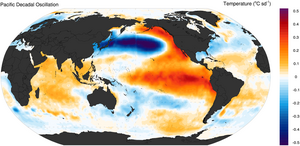
Recall that the PDO was a prominent and in my view, primary player in the 2014-2015 winter. For consecutive months that season, the index was measured at its highest positive value in recorded history. It remained positive through last season but it's influence was likely overwhelmed by the Super Nino. Here are some of the recent values.
The critical switch into positive territory took place during the 2013-2014 winter and the catalyst was a large body of anomalous warmth in the Gulf of Alaska that has remained present as of late 2016 though in a weaker state. Notice also that we saw another big positive PDO surge in the spring of this year but the index has since receded and seems to have settled into a mildly positive state as of Thanksgiving. Though I might prefer a positive to a negative phase, weak phases in either direction are not especially predictive. We've also had some snowy winters during big "negative phase" years because other factors may have overwhelmed the influence of the PDO. Last year of course, our substantially positive PDO was overwhelmed. So now that I have wasted your time discussing it, I am reducing the coefficient of influence for the PDO this year because of its weakened state.
As many within the community are already aware, this has not been the easiest last few months. An awful tragedy on Interstate 89 in October, has robbed us of 5 young and promising individuals. For those that follow the blog from out of the state, the news might have been lost in what has been tumultuous election season, but it was devastating turn of events. All I can say to those directly impacted by this, and I am sure I can speak for all of us faithful MRG skiers, many of us parents, is that we're thinking of you and wishing you the best going forward.
A few might have seen the fine piece that Emma Cotton at Vermont Ski and Ride put together where a bunch of us prognosticators shared our views of the upcoming season. This was done way back in August however and I always reserve my right to change opinions as I see fit. That said, many of those opinions haven't changed. There's reasons for optimism and reason for concern as of Thanksgiving week 2016.
Our biggest positive going into the season is undoubtedly the elimination of the 2016 Super Nino. This particular ENSO event was the biggest culprit of our miserable season last year. It was the 2nd strongest El Nino in recorded history which dates back almost 70 years. It had a profound impact on temperatures across Vermont, North America and across the globe as a whole. When combined with the effects of climate change, the first 8 months of 2016 set global land and sea temperature records. The El Nino fizzled as of late spring/early summer and by September we finally stopped setting global temperature records. The especially strong El Nino's has an even greater impact on temperatures over the more northern latitudes of North America so believe me it is the guest we are happy to do without on this thanksgiving holiday. My opinions of El Nino are not monolithic. Weaker versions of what we had last year have proven to help produce big winters in Vermont and some of the biggest east coast winters have occurred with the presence of weak and even moderate El Nino's.
As of late summer, there was certainly a degree of concern regarding where the state of the ENSO would be for the upcoming winter. Waters in the equatorial Pacific were cooling rapidly and some of the modeling suggesting that a significant La Nina event would emerge by autumn. This happened following the Super Nino of '97-'98 when we moved directly into a significant La Nina. The winter wasn't a catastrophe but was mitigated by numerous rain/ice events during the peak of the season and those types of personality traits often characterize many La Nina winters in Vermont. But after waters in those critical regions of the Pacific cooled in the spring, they subsequently stopped cooling in the summer and the state of the ENSO has stabilized on the La Nina side of neutral. We've had a few bad winters that were ENSO-neutral but if you average the 40-plus winters in recorded history in this category, snowfall in northern Vermont is about 5-10 percent above average and temperatures are slightly below average. I like the more empirical approach of simply tallying the amount of catestrophic winters that have occurred during ENSO-neutral years. I came up with only 7 (plus or minus one or two) although two of them have occurred recently (2005-2006 and 2001-2002). 2011-2012 was on the fence of an ENSO neutral winter. The cross section of 70 years suggests slightly less than a 20 percent chance of an awful winter occurring given the state of the ENSO and this is certainly an encouraging baseline.
The Pacific Decadal Oscillation or PDO also seems ready to assist this winter. The PDO has earned its way into every preseason discussion going back to the early days of the SCWB. The index measuring the state of the PDO is determined by the configuration of sea surface temperatures in the mid-latitude Pacific Ocean. I keep it all straight in my head by thinking of it as colorized horseshoes with the colors indicating SST anomalies. A "red" horseshoe such as the one in the below image describes a PDO in a positive phase while the "blue" horseshoe describes a PDO in a negative phase.
Recall that the PDO was a prominent and in my view, primary player in the 2014-2015 winter. For consecutive months that season, the index was measured at its highest positive value in recorded history. It remained positive through last season but it's influence was likely overwhelmed by the Super Nino. Here are some of the recent values.
YEAR JAN FEB MAR APR MAY JUN JUL AUG SEP OCT NOV DEC
2013 -0.13 -0.43 -0.63 -0.16 0.08 -0.78 -1.25 -1.04 -0.48 -0.87 -0.11 -0.41
2014 0.30 0.38 0.97 1.13 1.80 0.82 0.70 0.67 1.08 1.49 1.72 2.51
2015 2.45 2.30 2.00 1.44 1.20 1.54 1.84 1.56 1.94 1.47 0.86 1.01
2016 1.53 1.75 2.40 2.62 2.35 2.03 1.25 0.52 0.45 0.56 The critical switch into positive territory took place during the 2013-2014 winter and the catalyst was a large body of anomalous warmth in the Gulf of Alaska that has remained present as of late 2016 though in a weaker state. Notice also that we saw another big positive PDO surge in the spring of this year but the index has since receded and seems to have settled into a mildly positive state as of Thanksgiving. Though I might prefer a positive to a negative phase, weak phases in either direction are not especially predictive. We've also had some snowy winters during big "negative phase" years because other factors may have overwhelmed the influence of the PDO. Last year of course, our substantially positive PDO was overwhelmed. So now that I have wasted your time discussing it, I am reducing the coefficient of influence for the PDO this year because of its weakened state.
For the 5th October in a row, snow cover in the Northern Hemisphere "killed it" as measured in millions of square km. I would guess this hasn't gone unnoticed among scientists and researchers looking at such data with the obvious follow up questions emerging. Does the big expansion of snow cover in the NH during recent autumn months related to the low levels of arctic sea ice in recent late summer and early autumn months caused by the warming planet. 5 consecutive snow covered Octobers could also simply be statistical noise. Either way, we like to see the large amounts of autumnal snow since I believe it optimizes the "pooling" ability of polar airmasses. This recent October was the 3rd highest coverage of snow in 50 years or recorded data, just besting October of 2013 which preceded a chilly winter.
Like with the PDO, the relationship isn't linear nor is it perfect. In addition we have seen a very slow expansion of arctic sea ice this year which can certainly be attributed to the 8-plus months of record-setting land/sea temperatures dating back to late 2015. The Hudson Bay, which is relatively close to us in a global sense is only just beginning to accumulate some ice compared to many years where this body of water is a quarter to a half frozen over by now. So although I am excited about the build-up of snow over land, I am hedging the excitement because of the slow expansion of sea ice.
This season's outlook finishes the same way it has the last few seasons. Has mother nature, in poker parlance, revealed any "tells" this autumn ? To put it another way, is there a behavioral characteristic about the weather in Vermont the last few months that foreshadows how the weather might behave throughout the winter season. This kind of approach might not seem scientific, but I've found it to be a useful way to simplify the complicated and chaotic relationship between the causes and effects of atmospheric events and all the feedbacks in between.
What stands out the most, at least in my opinion, regarding the behavior of the weather the past few months is the inability to sustain below normal temperatures for any significant period of time. When the region does get an occasional burst of cold, the outbreak hasn't been especially strong; in fact, only 1 day in the past 3 months has seen temperatures of 10 or more below average. The period beginning in August and ending in October was the 3rd warmest dating back over a century.
This is the most disturbing observation going into the winter season. There many reasons one could attribute the recent stretch of warm weather to but fighting "persistence" is a very difficult chore. More often than not, if the weather is behaving in a certain way it will continue to behave that way. Using the same logic however, we certainly could be more optimistic about snowfall. The few times we've had below normal temperatures in October and November, we've gotten snow. Furthermore, the mountains of interior New England seem to be the favored locations for the heftiest accumulations. I would estimate that over 20 inches of snow has already fallen at Mad River which is already about 20 percent of what we managed to scrounge out last year.
Summarizing all this gobbledygook makes the forecast picture look as follows. In spite of the neutral state of the ENSO, a slightly positive PDO and a big expansion of autumnal snow and ice, temperatures will likely (not definitely) be on the above side of average. By no means do I expect the mild onslaught that we saw last year; in fact, I fully anticipate a healthy stretch of cold weather. Overall temperatures I would expect temperatures to average 1-3 above average which would be a massive improvement over last year. We should also do substantially better on snowfall. By the end of the season, I would guess that our seasonal snow amounts will be in the vicinity of average. My boldest prediction involves the elimination of the Vermont snow hole. I expect us to do just fine in a relative sense with the favorable patterns producing good powdery periods. The thaws will be there as well, and we I would expect a multi-week stretch of crappy weather and little snow which is certainly not at all unusual in Vermont.
Hope everyone is enjoyed or has enjoyed their thanksgiving holiday (depending on when you stumble upon this). Let the blogging begin again, I think we will have a lot more to talk about this year !
Subscribe to:
Posts (Atom)
