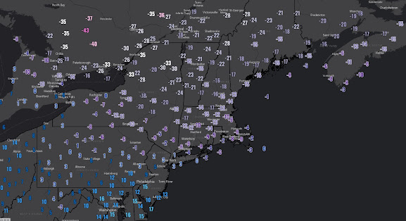
In an otherwise mild winter, Vermont and the rest of New England got slammed with one of the more intense outbreaks of arctic air this century and it stands up pretty well against many of the big ones in the 20th century. Even stations such as Boston's Logan Airport, now in its 100th year of operation (with 100 years of weather data), saw readings drop to -10 early Satuday shattering the lowest recorded temperature for the date by 8 degrees. Mt Washington has data going back 75 years and the -47 F degree reading early Saturday morning was the coldest ever recorded at the station at any time while the -110 degree wind chill scored international headlines and viral videos. Below is a map of low temperatures Saturday morning across the northeast U.S. and southeast Canada (Thanks Ian Livingston of the Capital Weather Gang).
The MRV saw temperatures stabilize around -20 early Saturday morning before rising above zero and continuing that rise Saturday night. By Sunday afternoon, many areas were above freezing bringing to mind the famous line from the 90's movie The Usual Suspects.... "and just like that, he's gone".
I don't have a ton of nice things to say about the prevailing weather pattern for the next two weeks and the blogosphere can get a little high on superlatives anyway, but lets just call it a challenging situation through Friday, February 17th. The upcoming week is mild, but at least the high country will mix in intervals of sub-freezing temperatures. Across the high country, most of Monday and Tuesday is sub-freezing and a clipper system approaching late on Tuesday is actually going to bring an inch or two of snow for the ski day on Wednesday. The concern for the shorter term forecast picture relates to Friday as a low pressure conglomeration arrives as arctic air continues a slow retreat northward in Canada. During the last update, I did include a poorly worded discussion conveying some potential with the weather situation on the weekend of February 11th and 12th, but with cold continuing to erode on Thursday into Friday, it will be difficult for precipitation to begin as anything but freezing rain or rain. I would expect this wet weather to begin late Thursday and continue into early Friday with temperatures generally staying in the 30's or 40's.
Things get more interesting later Friday into Saturday as a stronger piece of jet energy arrives along with marginally colder air. Models remain divided on how all this plays out but over the last several days, there's been a loose consensus for a period of snowfall of the elevation sensitive and potentially wet variety. Any snow would clear out by early Sunday which appears to be a blustery but dry day and may include a bit of sunshine.
The collection of unfavorable teleconnection indices are indicated to really produce some damaging weather conditions for us toward the middle to end of next week. Ensembles have repeatedly been showing a pattern amplification out across western North America in this time frame and this should make for some terrific snow conditions in the central and southern Rocky Mountains but it really puts New England on the defensive and raises the risk of a damaging thaw considerably. Now I've seen the ensembles advertise very adverse weather conditions in the longer range many times and sometimes it turns out even milder and torchier than I would have possibly imagined while other times the pattern ultimately turns out flatter and doesn't end up damaging at all.
Unlike last month, arctic air is expected to remain in North America, ultimately repositioning itself farther west next week as I mentioned in the above paragraph but also eventually restrengthening its hold on Canada in the last third of the month. There are not overwhelming indications that the pattern will revert back to widespread cold and storminess in eastern North America but the outlook does start to look colder at least in New England in that time frame.


No comments:
Post a Comment