Following 4 inches of fluffy snow, sunshine emerged in a big and beautiful way Tuesday afternoon. January has not been an easy month for winter weather and snow in northern New England, but we managed a decent finish and Tuesday was a terrific way to end it. The clear skies Tuesday night and fresh snow cover will allow temperatures to drop below zero, something we didn't do at all in January amazingly but most of us will break that streak on the first day of February. Depending on where you are (west or east), Tuesday or Wednesday all marks the first 5:00 pm sunset of the year. I had thought there was a chance it might be the last sub 5:00 pm sunset ever, though it appears the elimination of EST got caught in a legislative snarl and put on hold for the time being. Personally, I am a bit ambivalent on the whole thing. Though I don't particularly enjoy when it gets dark so early, the early winter sunsets have become rather engrained in New England tradition and it makes the brighter days of February and March something to look forward to. I might add that no matter how much we fail to act regarding climate priorities, climate change will never impact early winter sunsets !
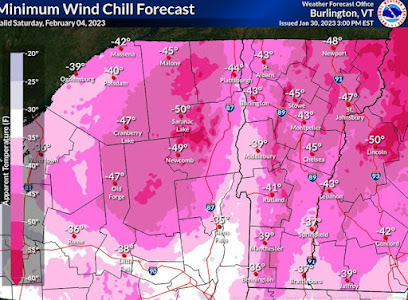
The drier weather that begin during the second half of Tuesday will continue through a roller coaster temperature regime over the next few days. We can expect some sunshine to return for Wednesday with temperatures climbing to about 20 followed by more clouds and more wind for Thursday along with temperatures that climb to 30. A massive arctic front will be approaching Thursday evening and a clipper system associated with this surge in frigid temperatures is expected to bring a period of snow to northern Vermont Thursday night. This however, is a brutally cold but very stable frontal assault of arctic air and I am expecting sunshine to return for Friday to go along with strong winds and dangerous wind chills. The National Weather Service in Burlington posted a wind chill forecast applicable for early Saturday but I think this map would be valid most of Friday evening into early Saturday.
Actual temperatures will start Friday below zero and stay below zero all day, perhaps as low as -10 to -20 at the summits. By Friday morning, readings everywhere will be close to -20 so although this will most assuredly not be a cold winter, this is quite assuredly a very cold outbreak of air for northern New England. Temperatures are expected to recover some during the day Saturday with the help of an almost full day of sunshine. Readings might make it above zero at the base as winds gradually abate. Clouds are expected to return on Sunday and winds should be gusty out of the southwest allowing readings to climb from near zero F, all the way back toward the freezing mark. A clipper system, again, well to our north, is responsible for the clouds, but the limited moisture might be too limited to support any snowfall. We have a better chance for some new snow on Monday as arctic air tries to give us a short encore performance opening up an opportunity for terrain enhanced snowfall even though a storm for early next week does not appear like it will materialize.
So now off to the not so great news. The weather pattern pretty clearly is poised to take a turn for the worse. We can keep our recent stretch of winter going through Tuesday, February 7th, but model data has moved aggressively toward a wind-driven torch on Wednesday of next week (Feb 8). I would have told you this was a 50/50 outcome this past weekend or even on Monday, but a significant temperature spike of 50-degrees appears more likely as of this update. Fundamentally speaking, its becoming tougher to argue for anything else with the jet stream regime in the Pacific beginning to resemble the "evil empire" look I've come to despise while every other teleconnection index (AO, PNA, NAO) all turn mildly to moderately unfavorable. The spike in temperatures next week appears temporary with closer to normal temperatures returning for late in the week, but the pattern would support additional spikes in temperatures through Valentines Day. Embedded within this ugly overall trend were some hints of a potential snowfall for the weekend of February 11th and 12th, but temperatures never appear below normal and arctic air appears farther north in Canada than it did when I last updated. This would set up the 2nd full week of February as again being pretty mild with the risk of another substantial temperature spike.


1 comment:
i really really hope they never make DSP permanent. I've got a late chronotype and having to get the kids up so early all winter would be true pain. :( People can always choose to wake up early if they want to, but forcing everyone to do it seems cruel and unnecessary.
Post a Comment