Mild weather and a couple of upcoming rain events have put the more than proverbial damper on the excitement we had about a week ago. That said, the wet near term forecast will be followed by a more wintry outlook and all but ensures that December 2016 will make a welcome detour from the route taken by December 2015.
The pattern gripping the United States as a whole is not especially mild or arctic but rather stormy. One storm spinning it's way through the northern plains will eliminate a large chunk of last week's snow by early Thursday as it tracks up through Lake Superior and into eastern Canada. Modified Pacific air will envelop the region later Thursday and allow for the return of some snow showers and flurries to the mountains but accumulations will be minimal. The upcoming weekend will certainly see it's share of sub-freezing temperatures but the absence of arctic air will also allow readings to climb above the freezing mark for a few hours during each of the afternoons. None of this is particularly atypical for December.
The 2nd potentially wet weather event is not etched in stone. This system will intensify in the southern plains over the weekend and advance northeastward. There isn't much in the way of available cold air to work with and there is a growing consensus that the storm will track toward the eastern Great Lakes and thus the thinking is for an ice->rain situation. A lot can happen in 6 days however and the possibility for more snow or even base-building sleet entering this forecast period remains. I am not particularly optimistic but if the system can transfer it's energy from the Great Lakes to the coast, it could lead to a much different outcome early next week so don't completely tune this one out.
The arctic door swings open as we advance through the next week period. Much of the cold will focus it's attention on the western half of the country while New England remains on the milder side of average through roughly December 8th. Some of the longer range ensembles then show that the long wave pattern will get reinvigorated as the cold advances toward us allowing for the possibility for snow to accompany the colder weather during the weekend of December 9th to the 11th.
There has been some hype-casters floating around the internet predicting all sorts of extremes for the middle to back half of December and plenty of snow. There will be a lot more of this in the coming years as we become more fully emerged in the bait and click world of information. Weather is certainly not an exception when it comes to the inherent public appetite for sensationalism so hypecasters will always get attention. The data however does not point at all toward an extremely cold middle to back half of December. Cold weather will, as mentioned, dominate the weekend of Dec 9-11 along with some snow and the chilly temperatures should linger through part of the work-week that follows. Ensembles though continue to suggest a stormy rather than cold dominated outlook and this is supported mainly by the negative PNA which will keep the west more unsettled and snowy for the ski areas out that way. Out our way, I am hoping for more snow but additional pushes of mild air are going to present a challenge as they often do in December. I can say though with great confidence that the month won't disintegrate into the tropical-mudfest that 2015 turned into.
Tuesday, November 29, 2016

Thursday, November 24, 2016
The ENSO has been neutralized and winter 2016-2017 will have a much larger presence. Let the blogging begin !
Welcome back winter ! Given that you pretty much took the year off in 2015-2016, it's nice to see a sizable winter storm hit the Adirondacks, Green and White Mountains in the pre-Thanksgiving days. It's especially refreshing to watch a storm actually expend it's energy on Vermont as opposed to dumping the goods where they aren't wanted. We can only hope this is a sign of things to come.
As many within the community are already aware, this has not been the easiest last few months. An awful tragedy on Interstate 89 in October, has robbed us of 5 young and promising individuals. For those that follow the blog from out of the state, the news might have been lost in what has been tumultuous election season, but it was devastating turn of events. All I can say to those directly impacted by this, and I am sure I can speak for all of us faithful MRG skiers, many of us parents, is that we're thinking of you and wishing you the best going forward.
A few might have seen the fine piece that Emma Cotton at Vermont Ski and Ride put together where a bunch of us prognosticators shared our views of the upcoming season. This was done way back in August however and I always reserve my right to change opinions as I see fit. That said, many of those opinions haven't changed. There's reasons for optimism and reason for concern as of Thanksgiving week 2016.
Our biggest positive going into the season is undoubtedly the elimination of the 2016 Super Nino. This particular ENSO event was the biggest culprit of our miserable season last year. It was the 2nd strongest El Nino in recorded history which dates back almost 70 years. It had a profound impact on temperatures across Vermont, North America and across the globe as a whole. When combined with the effects of climate change, the first 8 months of 2016 set global land and sea temperature records. The El Nino fizzled as of late spring/early summer and by September we finally stopped setting global temperature records. The especially strong El Nino's has an even greater impact on temperatures over the more northern latitudes of North America so believe me it is the guest we are happy to do without on this thanksgiving holiday. My opinions of El Nino are not monolithic. Weaker versions of what we had last year have proven to help produce big winters in Vermont and some of the biggest east coast winters have occurred with the presence of weak and even moderate El Nino's.
As of late summer, there was certainly a degree of concern regarding where the state of the ENSO would be for the upcoming winter. Waters in the equatorial Pacific were cooling rapidly and some of the modeling suggesting that a significant La Nina event would emerge by autumn. This happened following the Super Nino of '97-'98 when we moved directly into a significant La Nina. The winter wasn't a catastrophe but was mitigated by numerous rain/ice events during the peak of the season and those types of personality traits often characterize many La Nina winters in Vermont. But after waters in those critical regions of the Pacific cooled in the spring, they subsequently stopped cooling in the summer and the state of the ENSO has stabilized on the La Nina side of neutral. We've had a few bad winters that were ENSO-neutral but if you average the 40-plus winters in recorded history in this category, snowfall in northern Vermont is about 5-10 percent above average and temperatures are slightly below average. I like the more empirical approach of simply tallying the amount of catestrophic winters that have occurred during ENSO-neutral years. I came up with only 7 (plus or minus one or two) although two of them have occurred recently (2005-2006 and 2001-2002). 2011-2012 was on the fence of an ENSO neutral winter. The cross section of 70 years suggests slightly less than a 20 percent chance of an awful winter occurring given the state of the ENSO and this is certainly an encouraging baseline.
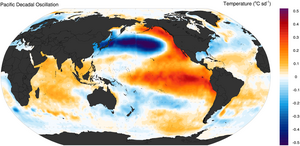
The Pacific Decadal Oscillation or PDO also seems ready to assist this winter. The PDO has earned its way into every preseason discussion going back to the early days of the SCWB. The index measuring the state of the PDO is determined by the configuration of sea surface temperatures in the mid-latitude Pacific Ocean. I keep it all straight in my head by thinking of it as colorized horseshoes with the colors indicating SST anomalies. A "red" horseshoe such as the one in the below image describes a PDO in a positive phase while the "blue" horseshoe describes a PDO in a negative phase.
Recall that the PDO was a prominent and in my view, primary player in the 2014-2015 winter. For consecutive months that season, the index was measured at its highest positive value in recorded history. It remained positive through last season but it's influence was likely overwhelmed by the Super Nino. Here are some of the recent values.
The critical switch into positive territory took place during the 2013-2014 winter and the catalyst was a large body of anomalous warmth in the Gulf of Alaska that has remained present as of late 2016 though in a weaker state. Notice also that we saw another big positive PDO surge in the spring of this year but the index has since receded and seems to have settled into a mildly positive state as of Thanksgiving. Though I might prefer a positive to a negative phase, weak phases in either direction are not especially predictive. We've also had some snowy winters during big "negative phase" years because other factors may have overwhelmed the influence of the PDO. Last year of course, our substantially positive PDO was overwhelmed. So now that I have wasted your time discussing it, I am reducing the coefficient of influence for the PDO this year because of its weakened state.
As many within the community are already aware, this has not been the easiest last few months. An awful tragedy on Interstate 89 in October, has robbed us of 5 young and promising individuals. For those that follow the blog from out of the state, the news might have been lost in what has been tumultuous election season, but it was devastating turn of events. All I can say to those directly impacted by this, and I am sure I can speak for all of us faithful MRG skiers, many of us parents, is that we're thinking of you and wishing you the best going forward.
A few might have seen the fine piece that Emma Cotton at Vermont Ski and Ride put together where a bunch of us prognosticators shared our views of the upcoming season. This was done way back in August however and I always reserve my right to change opinions as I see fit. That said, many of those opinions haven't changed. There's reasons for optimism and reason for concern as of Thanksgiving week 2016.
Our biggest positive going into the season is undoubtedly the elimination of the 2016 Super Nino. This particular ENSO event was the biggest culprit of our miserable season last year. It was the 2nd strongest El Nino in recorded history which dates back almost 70 years. It had a profound impact on temperatures across Vermont, North America and across the globe as a whole. When combined with the effects of climate change, the first 8 months of 2016 set global land and sea temperature records. The El Nino fizzled as of late spring/early summer and by September we finally stopped setting global temperature records. The especially strong El Nino's has an even greater impact on temperatures over the more northern latitudes of North America so believe me it is the guest we are happy to do without on this thanksgiving holiday. My opinions of El Nino are not monolithic. Weaker versions of what we had last year have proven to help produce big winters in Vermont and some of the biggest east coast winters have occurred with the presence of weak and even moderate El Nino's.
As of late summer, there was certainly a degree of concern regarding where the state of the ENSO would be for the upcoming winter. Waters in the equatorial Pacific were cooling rapidly and some of the modeling suggesting that a significant La Nina event would emerge by autumn. This happened following the Super Nino of '97-'98 when we moved directly into a significant La Nina. The winter wasn't a catastrophe but was mitigated by numerous rain/ice events during the peak of the season and those types of personality traits often characterize many La Nina winters in Vermont. But after waters in those critical regions of the Pacific cooled in the spring, they subsequently stopped cooling in the summer and the state of the ENSO has stabilized on the La Nina side of neutral. We've had a few bad winters that were ENSO-neutral but if you average the 40-plus winters in recorded history in this category, snowfall in northern Vermont is about 5-10 percent above average and temperatures are slightly below average. I like the more empirical approach of simply tallying the amount of catestrophic winters that have occurred during ENSO-neutral years. I came up with only 7 (plus or minus one or two) although two of them have occurred recently (2005-2006 and 2001-2002). 2011-2012 was on the fence of an ENSO neutral winter. The cross section of 70 years suggests slightly less than a 20 percent chance of an awful winter occurring given the state of the ENSO and this is certainly an encouraging baseline.
The Pacific Decadal Oscillation or PDO also seems ready to assist this winter. The PDO has earned its way into every preseason discussion going back to the early days of the SCWB. The index measuring the state of the PDO is determined by the configuration of sea surface temperatures in the mid-latitude Pacific Ocean. I keep it all straight in my head by thinking of it as colorized horseshoes with the colors indicating SST anomalies. A "red" horseshoe such as the one in the below image describes a PDO in a positive phase while the "blue" horseshoe describes a PDO in a negative phase.
Recall that the PDO was a prominent and in my view, primary player in the 2014-2015 winter. For consecutive months that season, the index was measured at its highest positive value in recorded history. It remained positive through last season but it's influence was likely overwhelmed by the Super Nino. Here are some of the recent values.
YEAR JAN FEB MAR APR MAY JUN JUL AUG SEP OCT NOV DEC
2013 -0.13 -0.43 -0.63 -0.16 0.08 -0.78 -1.25 -1.04 -0.48 -0.87 -0.11 -0.41
2014 0.30 0.38 0.97 1.13 1.80 0.82 0.70 0.67 1.08 1.49 1.72 2.51
2015 2.45 2.30 2.00 1.44 1.20 1.54 1.84 1.56 1.94 1.47 0.86 1.01
2016 1.53 1.75 2.40 2.62 2.35 2.03 1.25 0.52 0.45 0.56 The critical switch into positive territory took place during the 2013-2014 winter and the catalyst was a large body of anomalous warmth in the Gulf of Alaska that has remained present as of late 2016 though in a weaker state. Notice also that we saw another big positive PDO surge in the spring of this year but the index has since receded and seems to have settled into a mildly positive state as of Thanksgiving. Though I might prefer a positive to a negative phase, weak phases in either direction are not especially predictive. We've also had some snowy winters during big "negative phase" years because other factors may have overwhelmed the influence of the PDO. Last year of course, our substantially positive PDO was overwhelmed. So now that I have wasted your time discussing it, I am reducing the coefficient of influence for the PDO this year because of its weakened state.
For the 5th October in a row, snow cover in the Northern Hemisphere "killed it" as measured in millions of square km. I would guess this hasn't gone unnoticed among scientists and researchers looking at such data with the obvious follow up questions emerging. Does the big expansion of snow cover in the NH during recent autumn months related to the low levels of arctic sea ice in recent late summer and early autumn months caused by the warming planet. 5 consecutive snow covered Octobers could also simply be statistical noise. Either way, we like to see the large amounts of autumnal snow since I believe it optimizes the "pooling" ability of polar airmasses. This recent October was the 3rd highest coverage of snow in 50 years or recorded data, just besting October of 2013 which preceded a chilly winter.
Like with the PDO, the relationship isn't linear nor is it perfect. In addition we have seen a very slow expansion of arctic sea ice this year which can certainly be attributed to the 8-plus months of record-setting land/sea temperatures dating back to late 2015. The Hudson Bay, which is relatively close to us in a global sense is only just beginning to accumulate some ice compared to many years where this body of water is a quarter to a half frozen over by now. So although I am excited about the build-up of snow over land, I am hedging the excitement because of the slow expansion of sea ice.
This season's outlook finishes the same way it has the last few seasons. Has mother nature, in poker parlance, revealed any "tells" this autumn ? To put it another way, is there a behavioral characteristic about the weather in Vermont the last few months that foreshadows how the weather might behave throughout the winter season. This kind of approach might not seem scientific, but I've found it to be a useful way to simplify the complicated and chaotic relationship between the causes and effects of atmospheric events and all the feedbacks in between.
What stands out the most, at least in my opinion, regarding the behavior of the weather the past few months is the inability to sustain below normal temperatures for any significant period of time. When the region does get an occasional burst of cold, the outbreak hasn't been especially strong; in fact, only 1 day in the past 3 months has seen temperatures of 10 or more below average. The period beginning in August and ending in October was the 3rd warmest dating back over a century.
This is the most disturbing observation going into the winter season. There many reasons one could attribute the recent stretch of warm weather to but fighting "persistence" is a very difficult chore. More often than not, if the weather is behaving in a certain way it will continue to behave that way. Using the same logic however, we certainly could be more optimistic about snowfall. The few times we've had below normal temperatures in October and November, we've gotten snow. Furthermore, the mountains of interior New England seem to be the favored locations for the heftiest accumulations. I would estimate that over 20 inches of snow has already fallen at Mad River which is already about 20 percent of what we managed to scrounge out last year.
Summarizing all this gobbledygook makes the forecast picture look as follows. In spite of the neutral state of the ENSO, a slightly positive PDO and a big expansion of autumnal snow and ice, temperatures will likely (not definitely) be on the above side of average. By no means do I expect the mild onslaught that we saw last year; in fact, I fully anticipate a healthy stretch of cold weather. Overall temperatures I would expect temperatures to average 1-3 above average which would be a massive improvement over last year. We should also do substantially better on snowfall. By the end of the season, I would guess that our seasonal snow amounts will be in the vicinity of average. My boldest prediction involves the elimination of the Vermont snow hole. I expect us to do just fine in a relative sense with the favorable patterns producing good powdery periods. The thaws will be there as well, and we I would expect a multi-week stretch of crappy weather and little snow which is certainly not at all unusual in Vermont.
Hope everyone is enjoyed or has enjoyed their thanksgiving holiday (depending on when you stumble upon this). Let the blogging begin again, I think we will have a lot more to talk about this year !
Thursday, April 14, 2016
An agonizing Super Nino winter full of mild weather, missed storms and bad luck is in the books
As promised, even one of the lousiest MRG
season's in history deserves a wrap-up. It's painful even trying to
remember all of the early season warm weather and the opportunities lost
thereafter. 2015-2016 was a miserable winter and snow season in about
every statistical way and then some. Adding to the misery was the
repeated obscene gestures mother nature seemed to be throwing at us. In
the parlance of our times, weather geeks might refer to them as "screw
jobs". Get enough of these and one might refer to his location as a
"snow hole". In the common tongue a "screw job" is a storm that deposits
snow on seemingly every location but your own while a "snow hole" is a
region that gets repeated "screw jobs" throughout the year.
Typically, quantifying "screw jobs" and "snow holes" reveals that the term is used too loosely. Statistics manage to even out over time and missing one storm early in the year can be balanced out by getting "bullseyed" later in the season. I bring this all up because I actually wanted to do the analysis and see if the repeated misses this season actually turned central and northern Vermont into the "snow hole" we all perceived it to be. In doing such analysis it is vital that you keep climatology as a reference point so I looked at snowfall amounts across the northeast, the mid atlantic and even parts of Quebec and compared them all to their respective annual averages. Here are some of the results.
Location 2016 Avg Pct
Mad River Glen 112.0 240.0 46%
Burlington, VT 31.6 81.2 39%
Manchester, NH 28.4 61.4 46%
Caribou, ME 87.2 108.7 80%
Montreal, QC 61.1 85.6 71%
Jay Peak, VT 194.0 340.0 57%
Albany, NY 16.9 59.1 29%
Rochester, NY 62.3 99.5 63%
New York, NY 32.1 27.5 119%
Baltimore, MD 35.1 20.1 175%
Drawing maps on the internet is not my expertise but even doing this basic one is very revealing.

The map isn't perfectly drawn, but is a basic illustration of the above data. The Vermont "snow hole" was very real this winter. Places to our north such as Montreal and northern Maine outperformed us on a relative basis, as did places to our east along the Maine coast, as did places to our west such as the snowbelts of New York and the populated regions of southern Ontario. Areas to our south as New York City, Philadelphia and Washington, DC did exceptionally well relative to average all receiving between 125 and 175 percent of normal snowfall. Mad River Glen was not the worst location, but it was on the northeastern edge of the worst location so I am not accepting any consolation prizes. The corridor from southern Vermont through Albany to Binghamton, NY to Scranton, PA to Williamsport, PA was the worst place to be. All of these locations received under 35 percent of normal snowfall and some locations set records for the least snowiest season on record. Williamsport, PA has only recorded 6 inches of snow this winter, an incredibly depressing and dreadful result. Harrisburg, PA which is not even 100 miles down the Susquehanna Valley performed much better and the disparity can be explained away in one storm: the big January 22-23 Mid Atlantic blizzard that did Vermont no favors.
Though there was a promising build-up of snow across the northern hemisphere during the autumn months and the remnants of the two previous super "+ PDO" years remained in place, the dominating variable during the past year was the El Nino. I have been referring to this seasons big El Nino as the 4th "Super Nino" in recorded ENSO history dating back 65 years. A "Super Nino" is an El Nino winter where the critical ENSO measuring reasons feature water temperatures of more than 2 Celsius above average for a month. We have seen other "Super Nino" winters deliver decent though not great results and I certainly expected the mild weather to win the day in spite of the positive PDO and high late-autumn snow cover numbers. The snowfall forecast of "normal" however was way too optimistic and in retrospect was unlikely given some of the expected temperature anomalies. It is probably fair to say that the region was relatively lucky during the super El Nino of 1997-1998 and was equally if not more unlucky during the past winter season where less than half of usual amounts of snow accumulated on the mountain.
To recap, it was not a pretty start. The mild weather that prevailed in November intensified in December and turned the month into one of the mildest months relative to average since skiing began at Mad River Glen. I am sure no one working at MRG was thrilled about having the mountain closed during the Christmas holiday, but I was hopeful that we could simply put the adverse pattern behind us and out of the way and that the weather would deliver the same positive results of the recent 2006-2007 El Nino winter. There was every reason to believe that would happen as we approached New Years 2016. The menacingly strong jet stream in the Pacific which destroyed the month, relaxed substantially in January and outbreaks of cold weather and even some potential snow events finally appeared on the horizon.
The first big chance for a storm was on the weekend of January 9th and 10th. In the end, it was cold enough prior to the storm, cold enough in the wake of the storm and 40 degrees and raining during the storm. It would be the first of many events in the January-February time frame that either missed the region entirely or brought a drenching rain to a snow-starved mountain. The two weeks that followed did feature sub-freezing temperatures and some modest snowfall. The snow generally coming from clipper systems and Lake Champlain/terrain enhanced snow. As we approached the weekend of January 23rd and 24th however, a major storm became big news but not for the right reasons. Metropolitan areas, generally in the Mid-Atlantic region experienced a paralyzing blizzard but all of interior New England received little if any snow. By the end of January, more mild weather and even some rain left valley locations devoid of snow pack. Even the high country had a glaring lack of snow and we were once again closed for business by early February.
Most of February was even more agonizing. The first 7 days of the month were an abomination complete with both mild weather and rain. The pattern became more favorable in the weeks that followed but for the most part, we snatched defeat from the jaws of victory and found new and incredible ways to miss big storms. Terrain enhanced snowfall around February 10th and 11th provided the mountain with the best powder of the year and reopened most of the terrain for what turned out to be a brutally cold holiday weekend. The weather remained true to its 2015-2016 character however and in the worst traditions of New England winter weather. Within 2 days of -15 degree temperatures, it was raining yet again with readings in the 40's and deteriorating snow. Just over a week later we saw more of the same, rain and another lost opportunity at a big storm. Models continuously struggled to provide any clarity and were full of false alarms for a variety of reasons. Most of this just simply rubbed salt in the proverbial wound. A week of cold weather in early March brought with it another storm that managed to miss all of New England and provide decent snows to both Ontario and Quebec. It was all over after that as mild weather reestablished control over much of eastern North America and effectively ended the season.
These days, any mild season brings the topic of climate change or global warming right to the fore. I've said it many times that mixing seasonal, monthly, weekly, daily, geographical variability with a longer term trend such as what has occurred with global warming does not work on the debate stage and people continuously fall into the this trap. There are so many components of the seasonal variability equation which need to be measured and we discuss many on the blog and many others I leave out. Though "global climate change" is a component when predicting temperatures over the course of a winter season it remains a very small component. A Super Nino type winter season, such as the one we had will render it even smaller. I am not a denier; far from it actually, but raising awareness of the issue requires one to approach it from the appropriate scientific perspective.
Speaking in terms of seasonal variability, nothing seems to have the impact that can match that of a Super Nino as far as global land and sea temperatures are concerned. As mentioned, we have had 4 of these events in the 65 years of recorded history and every one has resulted in a 0.3-0.6 C rise in temperatures relative to average across the globe with higher numbers at higher latitudes. It is an astoundingly large figure which accounts for a substantial portion of the big global anomalies we saw in the December to February time frame this year. Those that refuse to accept the statistical reality of global warming loved to refer to 1998. It is the reference point that has reached legendary status among the deniers. How statistically convenient to use a record setting Super Nino as a starting point and then claim that the globe as cooled since then ! Take a look.
 Given
what we know about El Nino and what we also know about seasonal
variability, this argument is completely ludicrous. What is not
ludicrous would be to compare global temperatures this past winter
season with those that occurred during the last Super Nino, the
legendary reference point of 1998. Take a look at these global
temperatures anomalies.
Month 1998 2016
January 0.60 1.05
February 0.86 1.21
So with a Super Nino that was nearly equivilent if not a little weaker than 1998, global temperatures actually rose .45 C in January and .35 C in February. Such data just lends greater support to what we already know about the statistical global temperature trends. It is very noticable and very quantifiable. Those that want to claim the data is manipulated can simply resort to the empirical evidence such as the deterioration of glaciers, loss of ice in the Arctic, or the 9 trillion tons of ice lost in Greenland.
With election season approaching and given some of the data discusssed in the previous paragraphs, we may again see some light shed on the issue in the coming months. I just find it unfortunate that have yet to move beyond the point of proving the relevance of the data. There are two candidates that have said, given the chance, that they would like to abolish the EPA entirely and leave the environmental regulatory authority to the states. Though some states might behave it would undoubtedly in my view set up an arms race among other states to see who can be the most friendly to the big polluters. Furthermore, it degenerates the argument to the point where no big picture workable solutions can be agreed upon. I tell as many environmentally aware people as possible that simply getting into pissing matches with other environmentally aware people is not enough. The needle only gets moved if the skeptics can be won over. Environmental issues need to be embraced not only by liberals but also by conservatives. In this country we seem to be moving farther away from that every day. If you are a conservative, there is nothing out there that requires you to eat everything at the conservative buffet. You agree with 60, 70 or 80 percent of the platform yet reject the cynical view toward environmental issues such as what Christine Todd Whitman has done. It is the most viable path forward toward meaningful change.
Anyway, this miserable season is well behind us and the last of the snow is melting on the mountain. Next year, this El Nino will be severely weakened if not gone entirely. We are also through a season that featured some horrendous misfortune, some of which can simply attributed to a bad season at mother nature's slot machine. A repeat performance of that is highly unlikely. Enjoy the summer everyone and we will speak again as we approach the Thanksgiving holiday, hopefully with some snow to talk about.
Typically, quantifying "screw jobs" and "snow holes" reveals that the term is used too loosely. Statistics manage to even out over time and missing one storm early in the year can be balanced out by getting "bullseyed" later in the season. I bring this all up because I actually wanted to do the analysis and see if the repeated misses this season actually turned central and northern Vermont into the "snow hole" we all perceived it to be. In doing such analysis it is vital that you keep climatology as a reference point so I looked at snowfall amounts across the northeast, the mid atlantic and even parts of Quebec and compared them all to their respective annual averages. Here are some of the results.
Location 2016 Avg Pct
Mad River Glen 112.0 240.0 46%
Burlington, VT 31.6 81.2 39%
Manchester, NH 28.4 61.4 46%
Caribou, ME 87.2 108.7 80%
Montreal, QC 61.1 85.6 71%
Jay Peak, VT 194.0 340.0 57%
Albany, NY 16.9 59.1 29%
Rochester, NY 62.3 99.5 63%
New York, NY 32.1 27.5 119%
Baltimore, MD 35.1 20.1 175%
Drawing maps on the internet is not my expertise but even doing this basic one is very revealing.
The map isn't perfectly drawn, but is a basic illustration of the above data. The Vermont "snow hole" was very real this winter. Places to our north such as Montreal and northern Maine outperformed us on a relative basis, as did places to our east along the Maine coast, as did places to our west such as the snowbelts of New York and the populated regions of southern Ontario. Areas to our south as New York City, Philadelphia and Washington, DC did exceptionally well relative to average all receiving between 125 and 175 percent of normal snowfall. Mad River Glen was not the worst location, but it was on the northeastern edge of the worst location so I am not accepting any consolation prizes. The corridor from southern Vermont through Albany to Binghamton, NY to Scranton, PA to Williamsport, PA was the worst place to be. All of these locations received under 35 percent of normal snowfall and some locations set records for the least snowiest season on record. Williamsport, PA has only recorded 6 inches of snow this winter, an incredibly depressing and dreadful result. Harrisburg, PA which is not even 100 miles down the Susquehanna Valley performed much better and the disparity can be explained away in one storm: the big January 22-23 Mid Atlantic blizzard that did Vermont no favors.
Though there was a promising build-up of snow across the northern hemisphere during the autumn months and the remnants of the two previous super "+ PDO" years remained in place, the dominating variable during the past year was the El Nino. I have been referring to this seasons big El Nino as the 4th "Super Nino" in recorded ENSO history dating back 65 years. A "Super Nino" is an El Nino winter where the critical ENSO measuring reasons feature water temperatures of more than 2 Celsius above average for a month. We have seen other "Super Nino" winters deliver decent though not great results and I certainly expected the mild weather to win the day in spite of the positive PDO and high late-autumn snow cover numbers. The snowfall forecast of "normal" however was way too optimistic and in retrospect was unlikely given some of the expected temperature anomalies. It is probably fair to say that the region was relatively lucky during the super El Nino of 1997-1998 and was equally if not more unlucky during the past winter season where less than half of usual amounts of snow accumulated on the mountain.
To recap, it was not a pretty start. The mild weather that prevailed in November intensified in December and turned the month into one of the mildest months relative to average since skiing began at Mad River Glen. I am sure no one working at MRG was thrilled about having the mountain closed during the Christmas holiday, but I was hopeful that we could simply put the adverse pattern behind us and out of the way and that the weather would deliver the same positive results of the recent 2006-2007 El Nino winter. There was every reason to believe that would happen as we approached New Years 2016. The menacingly strong jet stream in the Pacific which destroyed the month, relaxed substantially in January and outbreaks of cold weather and even some potential snow events finally appeared on the horizon.
The first big chance for a storm was on the weekend of January 9th and 10th. In the end, it was cold enough prior to the storm, cold enough in the wake of the storm and 40 degrees and raining during the storm. It would be the first of many events in the January-February time frame that either missed the region entirely or brought a drenching rain to a snow-starved mountain. The two weeks that followed did feature sub-freezing temperatures and some modest snowfall. The snow generally coming from clipper systems and Lake Champlain/terrain enhanced snow. As we approached the weekend of January 23rd and 24th however, a major storm became big news but not for the right reasons. Metropolitan areas, generally in the Mid-Atlantic region experienced a paralyzing blizzard but all of interior New England received little if any snow. By the end of January, more mild weather and even some rain left valley locations devoid of snow pack. Even the high country had a glaring lack of snow and we were once again closed for business by early February.
Most of February was even more agonizing. The first 7 days of the month were an abomination complete with both mild weather and rain. The pattern became more favorable in the weeks that followed but for the most part, we snatched defeat from the jaws of victory and found new and incredible ways to miss big storms. Terrain enhanced snowfall around February 10th and 11th provided the mountain with the best powder of the year and reopened most of the terrain for what turned out to be a brutally cold holiday weekend. The weather remained true to its 2015-2016 character however and in the worst traditions of New England winter weather. Within 2 days of -15 degree temperatures, it was raining yet again with readings in the 40's and deteriorating snow. Just over a week later we saw more of the same, rain and another lost opportunity at a big storm. Models continuously struggled to provide any clarity and were full of false alarms for a variety of reasons. Most of this just simply rubbed salt in the proverbial wound. A week of cold weather in early March brought with it another storm that managed to miss all of New England and provide decent snows to both Ontario and Quebec. It was all over after that as mild weather reestablished control over much of eastern North America and effectively ended the season.
These days, any mild season brings the topic of climate change or global warming right to the fore. I've said it many times that mixing seasonal, monthly, weekly, daily, geographical variability with a longer term trend such as what has occurred with global warming does not work on the debate stage and people continuously fall into the this trap. There are so many components of the seasonal variability equation which need to be measured and we discuss many on the blog and many others I leave out. Though "global climate change" is a component when predicting temperatures over the course of a winter season it remains a very small component. A Super Nino type winter season, such as the one we had will render it even smaller. I am not a denier; far from it actually, but raising awareness of the issue requires one to approach it from the appropriate scientific perspective.
Speaking in terms of seasonal variability, nothing seems to have the impact that can match that of a Super Nino as far as global land and sea temperatures are concerned. As mentioned, we have had 4 of these events in the 65 years of recorded history and every one has resulted in a 0.3-0.6 C rise in temperatures relative to average across the globe with higher numbers at higher latitudes. It is an astoundingly large figure which accounts for a substantial portion of the big global anomalies we saw in the December to February time frame this year. Those that refuse to accept the statistical reality of global warming loved to refer to 1998. It is the reference point that has reached legendary status among the deniers. How statistically convenient to use a record setting Super Nino as a starting point and then claim that the globe as cooled since then ! Take a look.

Month 1998 2016
January 0.60 1.05
February 0.86 1.21
So with a Super Nino that was nearly equivilent if not a little weaker than 1998, global temperatures actually rose .45 C in January and .35 C in February. Such data just lends greater support to what we already know about the statistical global temperature trends. It is very noticable and very quantifiable. Those that want to claim the data is manipulated can simply resort to the empirical evidence such as the deterioration of glaciers, loss of ice in the Arctic, or the 9 trillion tons of ice lost in Greenland.
With election season approaching and given some of the data discusssed in the previous paragraphs, we may again see some light shed on the issue in the coming months. I just find it unfortunate that have yet to move beyond the point of proving the relevance of the data. There are two candidates that have said, given the chance, that they would like to abolish the EPA entirely and leave the environmental regulatory authority to the states. Though some states might behave it would undoubtedly in my view set up an arms race among other states to see who can be the most friendly to the big polluters. Furthermore, it degenerates the argument to the point where no big picture workable solutions can be agreed upon. I tell as many environmentally aware people as possible that simply getting into pissing matches with other environmentally aware people is not enough. The needle only gets moved if the skeptics can be won over. Environmental issues need to be embraced not only by liberals but also by conservatives. In this country we seem to be moving farther away from that every day. If you are a conservative, there is nothing out there that requires you to eat everything at the conservative buffet. You agree with 60, 70 or 80 percent of the platform yet reject the cynical view toward environmental issues such as what Christine Todd Whitman has done. It is the most viable path forward toward meaningful change.
Anyway, this miserable season is well behind us and the last of the snow is melting on the mountain. Next year, this El Nino will be severely weakened if not gone entirely. We are also through a season that featured some horrendous misfortune, some of which can simply attributed to a bad season at mother nature's slot machine. A repeat performance of that is highly unlikely. Enjoy the summer everyone and we will speak again as we approach the Thanksgiving holiday, hopefully with some snow to talk about.
Saturday, March 19, 2016
Euro cries wolf again and Vermont misses yet another storm
Hype for an east coast reached yet another fever pitch but it was as if many had forgotten the last 6 weeks. It is important to preface the following statement by saying that the European model and its ensembles have had many terrific calls and have many times pinned down specifics on some of the most important weather events in New England ahead of competing information. The last 6 weeks has been a complete abomination for the Euro however with several false alarms. In a year so devoid of snowfall in Vermont, crying wolf is certainly not going to win any hearts and minds.
Barring a miraculous turn of events in the 11th hour, the Sunday/Monday storm is a miss. Even the most optimistic scenario has the storm farther east by about 100 miles. The cape and even Boston could still receive some snowfall but much of New Hampshire and Vermont including the Green and White Mountains will receive next to nothing.
Chilly temperatures will still dominate the region and in fact may thwart the coming milder push of temperatures for a few days. Some snowfall is in fact possible on Tuesday and Wednesday across northern New England thanks to a nice overrunning zone established by the mild push of temperatures battling the existing cold weather. Snowfall accumulations could amount to a few inches before temperatures finally climb above freezing Thursday and perhaps reach the 50's on Friday.
Assuming nothing crazy happens, the blog will conclude with a seasonal wrap-up sometime next week before going into spring and summer mode.
Barring a miraculous turn of events in the 11th hour, the Sunday/Monday storm is a miss. Even the most optimistic scenario has the storm farther east by about 100 miles. The cape and even Boston could still receive some snowfall but much of New Hampshire and Vermont including the Green and White Mountains will receive next to nothing.
Chilly temperatures will still dominate the region and in fact may thwart the coming milder push of temperatures for a few days. Some snowfall is in fact possible on Tuesday and Wednesday across northern New England thanks to a nice overrunning zone established by the mild push of temperatures battling the existing cold weather. Snowfall accumulations could amount to a few inches before temperatures finally climb above freezing Thursday and perhaps reach the 50's on Friday.
Assuming nothing crazy happens, the blog will conclude with a seasonal wrap-up sometime next week before going into spring and summer mode.
Thursday, March 17, 2016
Sunday-Monday storm still not likely but remains in play for now
Winter makes a multi day cameo appearance in a month that has been generally middle. Rain and snow showers later Thursday become snow showers Thursday night producing a few inches of accumulation across the high country. Friday will be a rare blustery, sub-freezing day along with a few flurries. Saturday is high and dry with temperatures topping out right around the freezing mark after starting out in the 5-10 range.
The potential storm is still in play. The European model suggests a decent sized storm close to 980 mb tracking just east of Cape Cod. Vermont would be on the western side of some heavy snow while portions of New Hampshire get clobbered with well over a foot. This is the best case scenario for Vermont and includes about a 6-12 inch snow late Sunday into early Monday. Other models have been and continue to be further off shore with this system and weaker as well. The European has been living in its own fantasy-land with many of these systems over the last month-plus so I am extremely reluctant to sell my soul to another one of its snowy solutions. That said, it does have some support from its ensemble members as of early Thursday morning so it remains worthy of watching.
Though cold weather will linger through Tuesday March 22nd, the pattern continues to look extremely mild from the 23rd to about the 30th of the month. This could include another 1, 2 maybe even 3 days of readings in the 60's in this stretch. Ensembles do show the build-up of a ridge along the west coast around March 31-April 1 and this could lead to an outbreak of colder weather around that time.
The potential storm is still in play. The European model suggests a decent sized storm close to 980 mb tracking just east of Cape Cod. Vermont would be on the western side of some heavy snow while portions of New Hampshire get clobbered with well over a foot. This is the best case scenario for Vermont and includes about a 6-12 inch snow late Sunday into early Monday. Other models have been and continue to be further off shore with this system and weaker as well. The European has been living in its own fantasy-land with many of these systems over the last month-plus so I am extremely reluctant to sell my soul to another one of its snowy solutions. That said, it does have some support from its ensemble members as of early Thursday morning so it remains worthy of watching.
Though cold weather will linger through Tuesday March 22nd, the pattern continues to look extremely mild from the 23rd to about the 30th of the month. This could include another 1, 2 maybe even 3 days of readings in the 60's in this stretch. Ensembles do show the build-up of a ridge along the west coast around March 31-April 1 and this could lead to an outbreak of colder weather around that time.
Monday, March 14, 2016
Winter is on life support but will try to make one big last gasp this weekend
To be perfectly frank, I am ready to put the 2015-2016 winter season in the rear view mirror. March however, is typically the best part of the MRG season and in many years is the snowiest of all the winter months in Vermont.
We are still in the midst of a stretch of milder weather which will persist through a good part of the week. With the help of some sunshine on Wednesday, temperatures might again make a run at the 60-degree mark but clouds and some rain very late in the day might thwart that effort. Cooler weather will begin to slowly work its way back into the region Thursday; in fact, leftover moisture might result some limited snow across the high terrain while light rain falls in the valley locations. Friday begins a limited multi-day stretch of colder weather, perhaps the last such stretch this month.
Though Friday and Saturday look dry along with temperatures just below the so called "normal" threshold, a storm system will try and organize during the weekend combining jet energy in the plains with southern branch moisture in the Gulf of Mexico. Whether or not this all comes together correctly remains a question but there is a decent chance for some sort of east coast event Sunday the 20th into Monday, March 21st. Yes, one of the scenarios does call for a decent interior New England hit. The storm system would lack the strength to be historic storm but could produce as much as 12-18 inches of snow. That would be the upside. The downside is another in a litany of misses for Vermont this year.
Cold weather will continue to grip the region through the 22nd but will give way to more mild weather for the last week of the month. The limited blocking that was supporting the cold weather around the Spring Equinox will deteriorate plus the jet in the Pacific is expected to tighten. The storm late this weekend may be the last chance for a significant taste of winter though as Eric at MRG said, stranger things have happened.
We are still in the midst of a stretch of milder weather which will persist through a good part of the week. With the help of some sunshine on Wednesday, temperatures might again make a run at the 60-degree mark but clouds and some rain very late in the day might thwart that effort. Cooler weather will begin to slowly work its way back into the region Thursday; in fact, leftover moisture might result some limited snow across the high terrain while light rain falls in the valley locations. Friday begins a limited multi-day stretch of colder weather, perhaps the last such stretch this month.
Though Friday and Saturday look dry along with temperatures just below the so called "normal" threshold, a storm system will try and organize during the weekend combining jet energy in the plains with southern branch moisture in the Gulf of Mexico. Whether or not this all comes together correctly remains a question but there is a decent chance for some sort of east coast event Sunday the 20th into Monday, March 21st. Yes, one of the scenarios does call for a decent interior New England hit. The storm system would lack the strength to be historic storm but could produce as much as 12-18 inches of snow. That would be the upside. The downside is another in a litany of misses for Vermont this year.
Cold weather will continue to grip the region through the 22nd but will give way to more mild weather for the last week of the month. The limited blocking that was supporting the cold weather around the Spring Equinox will deteriorate plus the jet in the Pacific is expected to tighten. The storm late this weekend may be the last chance for a significant taste of winter though as Eric at MRG said, stranger things have happened.
Monday, March 7, 2016
A mild and somewhat rainy upcoming two weeks still expected
Nothing new or exciting to report as of March 7th. Pattern is still poised to turn very warm and stay that way for a better part of the next two weeks. Readings might get close to the 60-degree mark across valley locations Wednesday with 50's across the high country. A front will drop south out of southern Canada late Wednesday and early Thursday bringing the chance for some light rain and temperatures that are less mild. Later on Thursday, a more organized wave of low pressure will move along that same boundary of temperatures and spread significant amounts of rain into northern New England later Thursday and Thursday night. It's ironic because this particular storm will take a relatively favorable track for snow but the pattern will have gotten so warm by late this week and available arctic air is so limited that the results, predictably, will be another swing and a miss. There is a chance that rain changes over to a period of snow across the high country early Friday leading to a wet accumulation, but that is after about an inch of rain.
The pattern does appear to want to return to normalcy around the time of March 20th. This is very late in the game however and lots of damage will have been done both from rain and from warm weather.
The pattern does appear to want to return to normalcy around the time of March 20th. This is very late in the game however and lots of damage will have been done both from rain and from warm weather.
Subscribe to:
Posts (Atom)
